Thursday, September 3, 2020

Quartzite Peak via Emigrant Meadow Lake

Near: Pinecrest
Distance: 36 Miles
Elevation: 6,300 to 10,400 feet
Vegetation: Pine forest and high meadows
Last Visit: August 2020
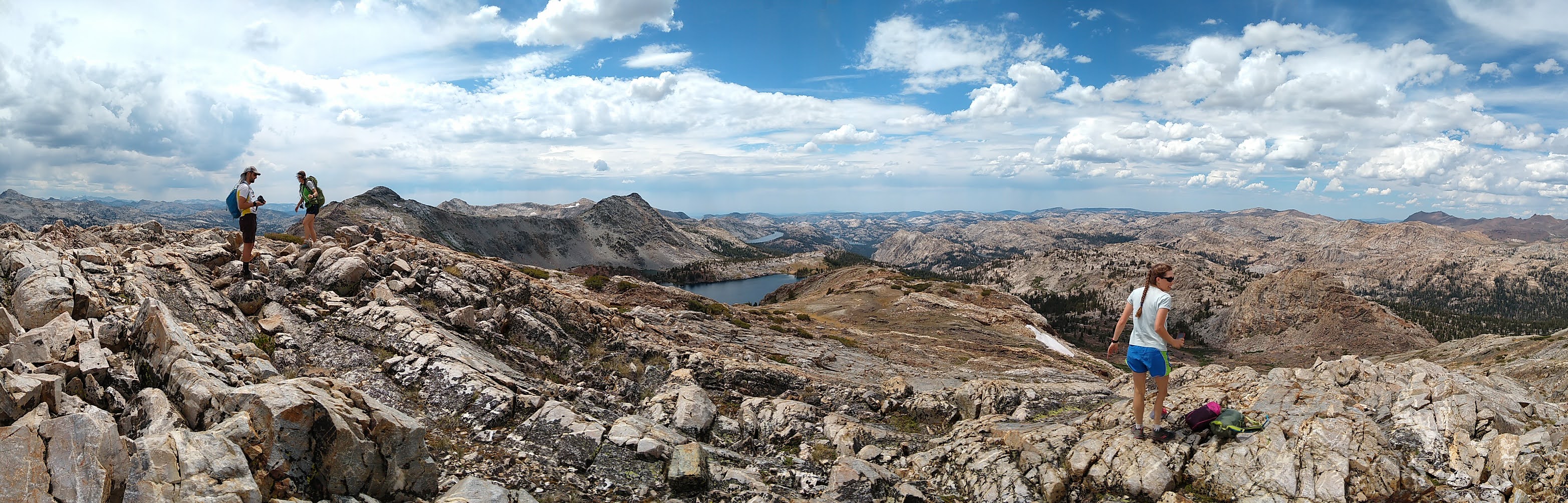
Quartzite peak is a broad peak along the boundary of the Emigrant Wilderness and Yosemite National Park. The views from the peak are outstanding with a great vantage over Emigrant, Bigelow, and Twin Lakes to the west and many dramatic peaks is Yosemite National Park to the south east.  You should only attempt this peak if you're comfortable with some off-trail travel.  Easy off-trail travel, but still off-trail. There is no official trail to the summit, but an old mining road is shown on some maps.  We found that road and followed it some of the way to the summit, but it's very faint and after a while it's just easier to go cross country up the open slope.

Getting to the final peak is quite a haul.  We did this trip as a three day backpack with a camp at Lunch Meadow and a long middle day with only day packs.  Another day or two would have brought down the intensity quite a bit.  Breaking the trip over more days would be easy to do with excellent potential camps at Relief Reservoir (that could get crowded on Friday/Saturday nights), Emigrant Meadow Lake, Grizzly Meadow, or Snow Lake. 

Take note that we saw many bow hunters out in the area around Bond Pass, the pass into Yosemite, so keep your pooch close in that area.  Also be ready to run into lots of horses and mules.  A pack station at the resort hauls people and their gear up to Emigrant Lake. I have never seen so many mules on any Sierra trail as here. We must of seen around 50 pack animals over the course of the weekend.


Sunday, August 30, 2020

Spine Ridge

Near: Moss Beach
Distance: 6 miles
Elevation 50 - 1200 feet
Vegetation: Coastal scrub
Last Visit: August 2020


The Spine Ridge Trail (aka Sully's Trail) is one of the few current access routes to the Rancho Corral de Tierra, and undeveloped chunk of the Golden Gate National Recreation area.  This is a new acquisition to the GGNR and building out the trailheads and official trail network will take many years likely.  Most of the trails now accessible to the public in the RCT have no good public parking options.  The Spine Ridge Trail at least is accessible via a dirt road that has space for a few cars to park.  The hike up Spine Ridge is much less nice than the nearby route up to the North Peak of Montara Mountain from Montara State Beach, but it's less crowded.  In theory you can reach that same sprawling ridge line from the Spine Ridge, but we haven't made it far up the trail (on our one visit we were turned around by worsening air quality from a bad season of summer wildfires as we hiked out of the marine layer).  It's also unclear to me how the rules work when crossing San Francisco Watershed land around the top of the ridge.  On the way into the trail you must pass through the Moss Beach Ranch / Ember Equestrian Center.  Please be respectful of private property and don't feed/pet the livestock.  (They have many signs to this effect around the ranch so I guess that's sometimes a problem).

Sunday, August 9, 2020

Pyramid Peak

Near: Placerville
Distance: 6 Miles
Elevation: 6,000 - 10,000 ft
Vegetation: Pine Forest to Moonscape
Last Visit: July 2020

Pyramid peak is a challenging day hike for humans, and the summit is particularly difficult for dogs.  There is no official trail up the mountain, but a well-worn use trail easily accessed from hwy 50 has become one of the more heavily used routes to any Tahoe area peak.  Because it was blazed by bushwackers, it's much more aggressive than most trails in the area, climbing around 4,000 feet in just over three miles. 

The finish is a fun scramble up 400 feet of jumbly boulders ranging in size from toaster ovens to refrigerators.  This summit is thus extremely challenging for dogs.  We think our whippet could have made it on his own when he was younger, bounding from rock to rock, but we ended up carrying him more than half the way up and most of the way down, which was quite tiring I can tell you.  Carrying a whippet up a flight of stairs is one thing.  Carrying one up a 400 foot tall pile of uneven boulders with lots of opportunities to slip and fall while you're feeling weak from a steep hike up to 10,000 feet is a different thing.  Doing that with a larger dog would have been hell. So don't start the summit section unless you're a strong hiker and confident you can carry your dog out, because if the bounding from rock to rock is too much for them they could really hurt themselves here. Exercise caution! 

If this sounds too much for your dog, but a steep dirt ramp up to 10,000 feet sounds fine, you can still hike up to the base of the boulder pyramid and circle around to the northwest shoulder of the peak without any significant scrambling.  From there you gain an excellent view of Mt Price and the cirque above Sylvia Lake.  I do advise making the summit if you can, though, perhaps taking turns with a hiking partner with one munching on snacks and waiting with your dog down at the base of the pyramid, while the other scrambles up and takes it in for a few minutes.  In my opinion, in the whole of the Lake Tahoe Basin, the only equal view to summit's panorama over the Desolation Wilderness is the view over Lake Tahoe from the top of Mt Tallac.

Friday, August 7, 2020

Lillian Lake Loop

Near: Fresno
Distance: 12 miles
Elevation: 7500 - 9000 feet
Vegetation: Pine forest
Last Visit: July 2020


**Note: the Ansel Adams Wilderness was heavily impacted by the Creek Fire of 2020.  Check the Sierra National Forest website for up to date information on trail closures.** 
 
You really can't go wrong in the Ansel Adams Wilderness.  We usually access the Ansel Adams from the Bishop side of the Pacific Crest, but there's a huge chunk of it more easily accessed from the Fresno side.  I'd been eyeing a trip into this area for a while when wildfires pushed us off our planned route and some calling around turned up the last two open spots on the quota from the Fernandez trailhead on the Lillian Lake Loop.  We were quite pleased with our 'misfortune'.  This loop is doable as a day hike but makes for a nice moderate backpacking loop too.  The loop passes directly by two excellent alpine lakes and close enough for short side trips to three more.  While the loop doesn't hit any peaks or high passes, several spots along the trail afford wide views to the northwest.  I highly recommend making the detour to Chittenden Lake as the lake is very nice and the rocky benches on it's southern side afford the best views of the hike.  The best camp sites are around Lillian Lake, which also makes a convenient staging area for day hike to Rutherford Lake and/or Fernandez Pass to the north.

Monday, June 22, 2020

Silver Lake to Spanish Peak

Near: Quincy
Distance: 7 miles
Elevation: 5800 - 7000 feet
Vegetation: Pine forest and manzanita scrub
Last Visit: June, 2020


 **Note: this hike is very close to the by the North Fire Complex of 2020.  Check the Bucks Lake Wilderness website for up to date information on trails** 
 
Spanish Peak is a rather modest high point along the Pacific Crest in the Bucks Lake Wilderness, but the eastern flank of the peak is comprised of steep cliffs dropping a few hundred feet to cluster of small lakes. So even though it's low and mostly treed, the views are actually quite excellent. This route starts at the Silver Lake Campground on the lowest, largest of these lakes and climbs the steep rocky slope the the Pacific Crest.  I also recommend the side trip to Gold Lake, the prettiest of the four small lakes in the area.  Gold Lake is a popular overnight camping spot.

Grass Valley Bald Mountain

Near: La Porte
Distance: 4.5 Miles
Elevation: 5,000 to 6,250 feet
Vegetation: Pine Forest
Last Visit: June 2020


**Note: this hike was very close the to North Fire Complex of 2020.  Check the Little Grass Valley Recreation Area website for up to date information on trail closures.
 
Grass Valley Bald Mountain is a minor peak overlooking the Little Grass Valley Reservoir.  It's definitely not the most spectacular peak in the Sierra and I wouldn't make it your sole destination on a day you're driving a long way to hike a Sierra peak.  If you happen to be hanging about the reservoir or generally in the area, it does make for a nice moderate hike with a good balance of pay-off for the effort.  It's also one of the nicer low-elevation options in the Sierra, topping out around 6,250 feet so if you're getting impatient waiting for snow melt in the spring, it might be a good peak to start with.

Monday, June 15, 2020

Vargas Plataeu

Near: Freemont
Distance: 3.5 miles
Elevation: 900 to 1200 feet
Vegetation: Pasture
Last Visit: June 2020


Vargas Plateau Regional Park is yet another East Bay cowpark situated east of Freemont.  This post is for a moderate loop around the high portion of the park.  You can also hike up the steep trail from subdivisions at the base of the plateau, but to the extent this lesser visit park has something unusual to offer, it's the the wide open views available with relatively little climbing from the upper parking area.  Also it's not clear to me if there is any public parking close to the lower entrance.