Sunday, November 11, 2018

Inspiration Point (Lake Alpine)

Near: Ebbetts Pass
Distance: 2.5 miles
Elevation: 7,300 to 7,900 ft
Vegetation: Pine forest
Last Visit: June 2018
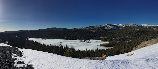
A still-frozen Lake Alpine from Inspiration Point in February 2018

Inspiration point is a small high point overlooking Lake Alpine west of Ebbetts Pass on California Highway 4.  The hike up to the overlook is fairly easy.  The rocky ridge can be gained in under a mile from the trailhead, affording great views of Lake Alpine to the north and the Stanislaus National Forest to the south.  The broad plateau at the summit has fine views in all directions including east to the Pacific Crest south of Ebbetts Pass.  Lake Alpine is a great destination as well with good swimming, some small rocky islands to explore and small boats for rent at the Lake Alpine Lodge.

Sunday, September 30, 2018

South Yuba River State Park: Hoyts Crossing Area

Near: Nevada City
Trip Type: Day Hike
Distance: 3 miles
Elevation: 1,200 to 1,500 ft
Vegetation: Transition between foothill oaks and Sierra pine forest
Last Visit: September 2018


South Yuba River State Park is one of just a few California state parks that allow dogs on trails.  The park consists of a series of disconnected chunks along the South Yuba river in the Sierra foothills.  In the late summer and early fall, a long string of cascades and swimming holes open up along the river as the water level drops, making it a favorite local swimming spot.  On our first trip to this park we headed upstream from the Hwy 49 crossing to check out some of the most choice swimming areas (though crossing points farther upstream allow for longer hikes).  We followed the maintained trail out of this section of state park for a bit less than a mile, then a half-mile or so of unmaintained use trails to some excellent water-carved rocks for lounging in the sun and jumping into the river.

Calero County Park

Near: San Jose
Trip Type: Trail Run
Distance: 5 miles
Elevation: 500 to 1,000 feet
Vegetation: Oak and pasture
Last Visit: September 2018


Calero County Park is yet another Bay Area tract of wide fire trails rolling over steep, lumpy hills dotted with oak trees.  It's pretty unremarkable in my opinion, though that's probably slanted by the fact I've only visited in late summer/early fall.  It will make for a much more pleasant landscape in later winter and spring when the grass is fresh and green.  This loop takes you over the most prominent ridge of the park, which offers sweeping views across the Santa Clara Valley towards Mt Hamilton to the east.


Saturday, August 18, 2018

Devils Bathtub

Near: Fresno (but not really)
Trip Type: Dayhike
Distance: 8 miles
Elevation: 7,800 to 9,200 feet
Vegetation: Pine Forest, Meadows
Last Visit: August 2018


**Note: the Thomas A Edison Lake and Florence Lake areas were heavily impacted by the Creek Fire of 2020.  Check the Sierra National Forest website for up to date information on trail closures.**

The ominously named Devils Bathtub (in the shadow of Graveyard Peak, no less) is actually a very pleasant alpine lake in the southern Ansel Adams Wilderness.  It's ringed with perfect blocky boulders for sunbathing or launching a nice cannon ball.  Most easily reached from the Mono Creek trailhead just off of Lake Thomas A Edison, the Bathtub is moderate hike on an easily followed trail with just enough climb to get you ready to jump in.

Wednesday, August 15, 2018

Florence Lake to Thomas A Edison Lake

Near: Fresno (but not really)
Trip Type: Backpack (2-4 days)
Distance: 25 miles
Elevation: 7,300 to 10,900 feet
Vegetation: Pine Forest, Meadows, and Moonscape
Last Visit: July 2018


**Note: the Thomas A Edison Lake and Florence Lake areas were heavily impacted by the Creek Fire of 2020.  Check the Sierra National Forest website for up to date information on trail closures.**

The John Muir Trail, from Mt Whitney to Yosemite Valley along the Pacific Crest, is one of the most famous trails in the world.   Much of this fabulous trail is off limits to dogs as it passes through Yosemite, Kings Canyon, and Sequoia National Parks, but not all of it.   A good 70 miles of continuous trail through the heart of the high Sierra is open to dogs though, as the trail passes through the John Muir Wilderness and Ansel Adam Wilderness between Yosemite and Kings Canyon.  Having already visited (and loved) some sections of the trail in the Ansel Adams Wilderness before, we decided to check out a southerly portion of this dog-friendly section, backpacking from Florence Lake to Thomas A Edison Lake by way of Seldon Pass and Marie Lake (picture above).  Ansel Adams still takes the prize on wow-factor, but this hike was almost as eye-popping and has an extra novelty factor from some optional boat rides at the start and end.  We did it in 4 days (really 3 days and a couple hours) but we spend a middle day goofing off in the high terrain around Mt. Hooper overlooking Lake Marie.  A fit group could do this hike as an overnight or even an epic day-hike, though making the ferries in time might be rough and leaving them out would add and extra 10 miles to the loop.


Friday, June 1, 2018

Mt. Tamalpais Fire Roads Loop

Near: Mill Valley
Trip Type: Trail Run
Distance: 8 miles (or 5 miles to West Point Inn and back)
Elevation: 900 - 2,300 ft (1,800 ft at West Point Inn)
Vegetation: Some pine forest, some scrubby manzanitas
Surface: Dirt with a lot of rock mixed in.
Last Visit: 5/28/18


I lived in the Bay Area for the better part of a decade before I realized that Mt. Tamalpais State Park only covers the bottom half of Mt. Tam and a tiny bit of the summit.  Most of the upper slopes are Marin municipal lands and the trails and fire roads there are open to dogs, provided they're on a leash.  The roads and trails around the summit make for a nice network with a mix of slow gradual climbs on wide fire roads and steeper single-track routes.   This post describes a circuitous tour up to the peak on the old railroad grade for a steady, satisfying trail run with lots of nice views of the San Francisco Bay.  You can also cut this down to a lighter run/hike with modest climb by popping out the the West Point Inn and back.

Saturday, April 28, 2018

Carson Pass Cross Country Ski Trails

Near: Carson Pass
Trip type: Cross Country Ski
Distance: 3-4 miles to the lake and back
Elevation: 8,600 to 8,200 feet
Vegetation: Pine Forest
Last Visit: April 2018


As the 2017-2018 ski season is drawing to a close, we finally got up to the back-country ski trails around Carson Pass.   These trails aren't groomed, but are clearly marked and easy to follow.  They do descend a few hundred feet from the parking areas at the Carson Pass and Meiss Meadow Sno Parks, so in icy conditions they'll be a little challenging for novice skiers.  On warm days with soft, consolidated old snow, they should make for a great intro to back country skiing for novice skiers with a bit of experience on groomed trails.  They end at a satisfying vista of Round Top from across Woods Lake.  We didn't explore any farther than Woods Lake, but the Forest Service Flyer on the trails suggests there's another marked trail leading up towards Winnemucca Lake, which would make a great destination for more intermediate/advanced skiers looking for a longer trip out.

Update 2019: Yup, there is a marked trail from Woods Lake up to the boundary of the Mokelumne Wilderness and it's easy to navigate from there up an open, sparsely treed valley to Winnemucca Lake.


Sunday, February 18, 2018

Hunter Creek Trail

Near: Reno, NV
Distance: 6 miles
Elevation: 5,000 to 6,100 feet
Vegetation: Desert scrub to pine forest
Last Visit: February 2018


Winter 2018 has been pretty sad in the snow department. Well into February we're in that awkward stage where there's enough snow at higher elevations to make lots of trails hard to follow, but not enough for good skiing and snow shoeing except the on the highest trails.  So on a weekend trip up to the Tahoe area we did a day of snowshoeing on Castle Peak and a light day on the Hunter Creek Trail on the west side of Reno at the base of the Mt Rose Wilderness.  This trail starts in the desert scrub at 5,000 feet and follows a canyon up to a modest waterfall just at the tree line around 6,000 feet.  As a real forest chauvinist this hike won't be making an top ten lists for me, but it was a nice change of pace.  The proximity of the trailhead to Reno and the steady, well-graded trail makes it a popular afternoon jaunt, so you'll have some company here.