Saturday, November 19, 2016
White Hill
Near: Fairfax
White Hill is a modest highpoint in Marin County near Fairfax. While the peak it's self is somewhat unremarkable, it does offer fine views of Mt. Tam and San Francisco to the south and across the San Francisco Bay to the east. The route up to the peak runs through a surprisingly varied landscape including a couple small stands of dense redwoods mixed in with typical Bay Area oak, chaparral, and grassland.Wednesday, November 9, 2016
Sierra Buttes
Near: Sierra City
Length: 7 miles
Elevation: 6,200 - 8,600 feet
Vegetation: Pine Forest
Last Visit: 11/05/2016
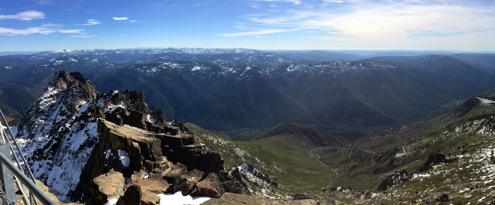
The Sierra Buttes are a dramatic cluster of volcanic spires at the northern edge of the Tahoe National Forest. Somewhat off the beaten path of the Lake Tahoe and High Sierra around Yosemite to the south, the Sierra Buttes are one of the most under rates spots on the Pacific Crest. An old forest service fire lookout sits at the summit, 4,000 feet above Sierra City and the Yuba River to the south and over 2,500 feet above the Sardine Lakes to the northeast with excellent views in all directions. There are a few options for climbing the summit, including a long climb up the south and west face from Sierra City along the PCT, and a few options converging on the north ridge. In the summer a 5 mile round trip is possible from Butcher Ranch Road above Packer Lake Saddle. We opted for a 7 mile route from near Packer Lake north east of the summit and passing Tamarack Lakes en route to the north ridge.
Wednesday, October 26, 2016
Mt Lola Trail
Near: Truckee
Trip Type: Hike
Distance: 10 miles (low estimate)
Elevation: 6,600 - 9,100 feet
Vegetation: Pine Forest
Surface: Dirt (and snow)
Last Visit: October 2016

It's October and the summer hiking season is coming to a close. We headed out to Tahoe National Forest just after the first snows of the season hit the region. We hiked Mt. Lola, an unassuming peak, just off the PCT north of the Donner Pass area. At a bit over 9,100 feet, Mt. Lola is the highest peak between I-80 and Mt. Lassen, yet it's usually overshadowed by all the more dramatic peaks around Lake Tahoe just to the southeast. The usual ascent from the north is a steady climb up a pleasant, but unremarkable creek drainage. The real payoff comes at the peak with fantastic views of the spires of Castle Peak to the south, and Sierra Buttes to the north.
Wednesday, October 5, 2016
Big Rock Ridge (Marin)
Near: Lucas Valley
Trip Type: Hike
Distance: 7 miles
Elevation: 600 - 1,900 feet
Vegetation: Pasture
Last Trip: October 2016

Big Rock Ridge is one of the higher ridges north of Mt. Tam in the Marin county open space. This very exposed hike is mostly nothing special, and communications towers at the summit mar the climax a bit, but the views south to Mt. Tam and San Fransisco, as well as east over the San Fransisco Bay are worth the climb if you've already seen the more unique trails and vistas on Mt. Tam and around the Marin Headlands. The climb is very steady and well graded, so this would be an excellent option for a trail run. Mountain bikes are common too, but all dogs must be on a leash, so that would make a ride plus dog a bit awkward.
Monday, September 26, 2016
Volmer Peak Loop
Near: Berkeley
Trip Type: Trail Run
Distance: 7.5 miles
Elevation: 700 - 1,800 ft
Vegetation: Mostly forested with a mix of deciduous, pine and grassy meadows
Surface: Hardpack dirt

Tuesday, August 30, 2016
Mission Peak
Near: Freemont
Trip Type: Hike
Distance: 5 miles
Elevation: 400 - 2500 ft
Vegetation: Pasture
Surface: Dirt
Last Visit: Sometime in 2014
Mission Peak Regional Preserve is no pristine wilderness. It's yet-another-East-Bay-dirt-road-grass-and-cows experience. Still, its proximity to Bay Area population centers and its satisfying prominence make it worth a visit when you're in the mood for a substantial climb, but not a substantial drive. It's also the far western terminus of the Ohlone Wilderness Trail, so this is the place to start if you want to go on a 28-mile trek into the East Bay hills with several thousand feet of climbing. Personally, if I'm going to do that much work, the Sierras or Trinity Alps better be involved, but if you live in the SF Bay and want to go backpacking with a dog on a strict carbon-footprint budget, then the Ohlone is the trail for you.Wednesday, August 24, 2016
Rodeo Beach, Wolf Ridge Loop, and Costal Trail from Muir Beach
Near: Sausalito
Trip Type: Hike
Length: 5 miles
Elevation: 0 - 800 ft
Vegetation: Coastal scrub
Surface: Paved and dirt
Last Visit: 8/20/16

Rodeo Beach and Muir Beach are some of the most scenic beaches north of San Francisco and both are dog friendly and the trails around these beaches are the nicest of the few dog friendly options in the Marin headlands. The most natural circuit is to climb up and around "hill 88" above Rodeo beach and explore the old WWII fortifications guarding the Golden Gate (voice control OK on this loop). For the best sweeping ocean views, start at Muir Beach and hike south along the Costal Trail (leash required).
Monday, August 22, 2016
Tells Peak
Near: Placerville/Hwy 50
Trip Type: Hike
Length: 11 Miles
Elevation: 6,500 ft - 8,900 ft
Vegetation: Forest and Meadows
Surface: Dirt
Last Trip: 8/13/16

Last weekend we wanted to find a dark spot to watch the Perseid meteor shower, so we headed up to Loon Lake campground west of Lake Tahoe. After watching the stars on Friday night, we spent Sunday hiking up to Tells Peak. A modest peak compared to many of it's neighbors, Tells Peak nevertheless makes a satisfying day hike capped with spectacular views. The trail is mostly easy to follow, but the higher bits require a bit more attention to follow a cairn chain to the ridge. So most hikers will find the navigation no challenge, but it's not the best trail to let your mind drift absently.
Sunday, August 21, 2016
Redwood Regional Park
Near: Oakland
Distance: 5 miles
Elevation: 500 - 1,000 ft
Vegetation: Redwood Forest
Last Trip: August 2018

On warm summer days, Redwood Regional Park offers some the coolest most shaded paths in the East Bay. It's not quite Muir Woods, but the park has several nice stands of relatively mature redwoods. In particular the stream trail along the creek in the deep central valley of the park and the french trail along the southwest slope of that valley are almost entirely covered in redwoods. On balance this park might be the best place in the state to get your fill of these stately trees with a dog.
Wednesday, August 3, 2016
Dicks Peak from Eagle Falls
Near: South Lake Tahoe
Trip Type: Day Hike
Length: 16 Miles
Elevation: 6,600 - 10,000 ft
Vegetation: Pine Forest to Moonscape
Surface: Mostly dirt to Dick's Pass, Rock and Scree to Dick's Peak
Last Visit: 7/23/16

Dicks Peak is the highest point in the Desolation Wilderness or anywhere on the west side of Lake Tahoe. Best hiked as an overnight or long day hike from trailheads on Emerald Bay or Fallen Leaf Lake. It's a long haul for a day hike as we did it, but our route offers several options for shorter turnaround points at Eagle lake (2 miles, round trip), an overlook (4 miles), Dick's Lake (8 miles), or Dick's Pass (12 miles). Be warned, though, the final ascent requires some rocky scrambling that's no trouble for most primates, but will beyond many dog/human combinations. Don't attempt the summit unless your dog is relatively spry and obedient, and you're confident you can hoist them down a few 4-foot drops on the descent. If that sounds fine and you enjoy a little scrambling and a great view, Dick's Peak makes for a very satisfying summit.
Sunday, July 24, 2016
Thousand Island Lake from Agnew Meadows
Near: Mammoth Lakes
Trip Type: Backpack (2-3 days)
Distance: 18 Miles
Elevation: 8,300 - 10,000 ft
Vegetation: Pine Forest, Meadows
Last Visit: 7/4/16

Just over the Sierra Crest from Yosemite National Park lies the Ansel Adams Wilderness. It is certainly one of the most beautiful places in California with high craggy peaks soaring over dozens of pristine lakes and cascading rivers. The slightly hyperbolicly named Thousand Island Lake is a popular destination deep in the wilderness area. We took a common loop there from Agnew Meadows via the John Muir Trail and the Pacific Crest Trail. Along the way this route passes several other gorgeous lakes and waterfalls. This loop would be doable in a long day hike, but it's more than worth spending a night or two at the lake and exploring the higher terrain. It's a long drive from northern California population centers, but it's more than worth it.
Sunday, July 10, 2016
Lake Mary to Duck Lake
Near: Mammoth Lakes
Trip Type: Hike
Distance: 8 miles
Elevation: 9,100 - 10,800 ft
Surface: Dirt
Vegetation: Sparse Pine Forest
Last Trip: 7/2/16

We spent Independence Day weekend out in the Mammoth Lakes area. Our first choice was to do a two-night backpack in the Ansel Adams Wilderness, but those overnight permits are in high demand and we could only get a permit for Sunday departure. While waiting in line for permits we got a tip for a nice dayhike nearby. I'm extending my always-listen-to-hike-suggestions-from-strangers-at-trailheads rule to ranger stations. The trailhead for this hike is a bit busy, but the crowds thin quite a bit as you climb. The trail passes three small lakes on the way to Duck Pass, each of which is a destination for anglers and family swimming expeditions. Topping out over Duck Pass you're treated to a beautiful view over Duck Lake.
Wednesday, June 29, 2016
Woodchuck Basin to Weaver Ridge
Near: Arnold/Lake Alpine
Trip Type: Hike
Distance: 7.5 miles
Elevation: 7,800 - 9,100 ft
Surface: Dirt and loose volcanic gravel
Vegetation: Pine forest to moonscape
Last Trip: 6/11/16

As the higher elevations started to open up for the summer, we went looking for hike with a lot of southern exposure. Wheeler ridge, runs east-west to the north of California highway 4, just east of Lake Alpine. And makes for a great early season peak. The trail winds gently up Woodchuck Basin through pine forest that gradually thins to a mostly open slope, then a completely open ridge with very little vegetation. The trail proper heads over the ridge and down a thousand feet to Wheeler Lake, but we struck east on the ridge, to a rocky high point where a little light scrambling brought us to a great perch with 360 degree views of the Mokelumne Wilderness to the north, the Pacific Crest to the East and Lake Alpine to the southwest. As a bonus, Lake Alpine makes for a great place to take a dip before the drive home.
Tuesday, June 21, 2016
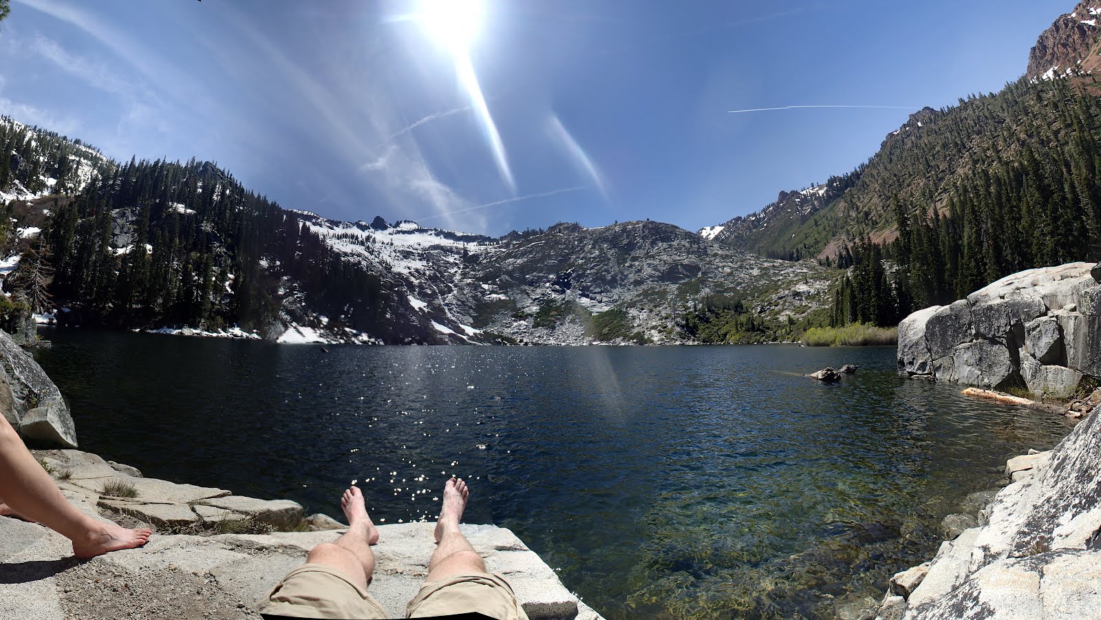
Boulder Lake and Little Boulder Lake
Near: Weaverville
Distance: 3.5 - 6.5 miles
Elevation: 5,800 - 6,400 ft
Surface: Dirt and Snow
Vegetation: Pine Forest
Last visit: 5/30/16

Boulder Lake and Little Boulder Lake are yet more scenic alpine lakes in the Trinity Alps. They're less spectacular than some other lakes in the Trinities, but they're a great choice if you're looking for scenic lake with only modest effort to get there. I liked Little Boulder Lake a bit more as Boulder lake was shallow and surprisingly muddy given it's name. There was still melt water flowing into it... but Little Boulder Lake looked like a great place for a swim in a month or two... Both lakes are in the shadow of rocky minor peaks. We scrambled up on the slopes of the one overlooking Boulder Lake (called Tapie peak, I'm told, though it wasn't labeled on our map), following an off-trail route we found on another blog, and were rewarded with views of nearby Tapie Lake and Mt. Shasta off to the north.
Wednesday, June 8, 2016
Granite Lake
Near: Weaverville
Distance: 10 miles
Elevation: 4,000 - 6,000 ft
Vegetation: Pine Forest
Last Visit: 5/29/16
Granite Lake was my favorite alpine lake out of the half dozen we visited in the Trinity Alps over the Memorial Day weekend. At 10 miles round trip, with 2,000 feet of elevation gain, the trip to Granite Lake it makes for a meaty day hike or moderate backpacking destination. The trip has fewer vistas than the nearby Canyon Creek Lakes hike, as it's deeper in a thickly treed valley, but it also climbs along a cascading creek with several scenic waterfalls that go almost unnoticed in the Trinities, but would be notable attractions themselves in the Sierras.
Sunday, June 5, 2016
Canyon Creek Lakes
Near: Weaverville
Trip Type: Day Hike
Distance: 18 miles
Elevation: 3,100 - 5,800 ft
Vegetation: Pine Forest
Last Visit: 6/5/2016

After a long Memorial Day weekend in the Trinity Alps, they've cemented their place as my favorite place in California. Yosemite is more draw dropping, but of course you can't hike with your dog there. The valleys in the Trinities are lower, and rain more plentiful, yielding a healthier, more vibrant ecology swimming with alpine lakes and streams. Canyon Creek Lakes are the headliner hikes for the Trinities for good reason. The trail is a straight shot up the a dramatic canyon with peaks towering 4,000 feet above you at points. The canyon is dotted with more than a half dozen scenic waterfalls and ends in two fantastic alpine lakes.
The only real negative about this hike is its over-popularity for backpacking. There are no entry quotas in place in the Trinity Alps Wilderness, so very popular routes like this one get overcrowded on holiday weekends. When we visited many backpacking groups were camping too close to the trail and stream and acting a bit passive agressive on the trail trying to send out their fastest hikers to claim choice campsites. Maybe it's best if things are kept this way on this trail, though, because seeing it stopped me complaining about entry quotas elsewhere.
At 18 miles round trip, a day hike to the upper lake is long, but very doable for avid hikers. There's nearly 3,000 feet of elevation gain, but it's a steady ascent with very little back-climbing. The trail is mostly very easy to follow so you can make good time. We made the round trip in 7 hours. If that still sounds like a bit of a death march to you, then you should still consider heading up the trail for a shorter hike. Starting about 3 miles in, there are sweeping views and waterfalls aplenty at regular intervals all the way up the valley. Even without making the lakes, it's still a great hike.
Wednesday, June 1, 2016
Loch Leven Lakes.
Trip Type: Hike
Near: Cisco Grove
Distance: 7 miles
Elevation: 5800 - 6800 ft
Vegetation: Pine Forest
Last Hike: May 2018

Lock Leven Lakes are a series of Alpine Lakes on the western slopes of the Sierra just west of the Sugar Bowl ski area. The modest climb required to reach them and their ease of access from I-80 make them a very popular destination, particularly in the spring and fall when snow is more of problem at higher elevations. The hike is mostly so-so at first, with some nice open granite sections, but the ambiance isn't great with road noise from I-80 for the first mile or two. But when you top out at the lakes it suddenly turns idyllic and beautiful. Note that while this is not a physically difficult hike, there the trail can be a bit hard to follow at few points, even though it's relatively heavily trafficked for the area. Getting to Upper Loch Leven Lake can be particularly challenging since the route shown on many maps is wrong.
Sunday, May 22, 2016
Del Valle to Murietta Falls
Near: Livermore
Trip Type: Hike
Distance: 14 miles
Elevation: 800 - 3500 ft
Vegetation: Forest, Scrub and Pasture
Last Hiked: May 8, 2016

**Note: This hike was affected by the 2020 SCU fire
complex. Check on official information for the Ohlone Regional Wilderness, for up to date information on the state of
trails there**
Murietta Falls are not particularly awe-inspiring, but they make for a just-reachable destination over a challenging and pleasant section of the Ohlone Wilderness Trail. All but a mile or so of this "Wilderness Trail" is a typical east bay fire road... but there's enough poison oak around you won't mind so little single track. At least 13 miles out and back with almost 3,000 feet of net elevation gain and significant back climbing, reaching the falls makes for no easy stroll. Most of the climb up to the best vista at Schlieper Rock is in forest and scrub land (as opposed to the grazed pastureland around Murietta Falls) so while I think "Wilderness" is a bit of a stretch, the landscape does feel more wild the most of the east bay. Let's call it a wildishness if not a wilderness.
Saturday, May 7, 2016
Indian Valley
Near: Novato
Trip Type: Trail Run
Distance: 4.5 miles
Elevation: 100 - 600 ft
Surface: Dirt and Rocky Dirt
Vegetation: Forest
Indian Valley is a small park in the Marin County Open Space system. It's less extensive and interesting than some of the nearby parks, and the lower parts have a very suburban feel, but it's a nice spot for a modest hike or trail run if you've done most of the higher profile trails nearby. I was out for a trail run there today in the rain without at map and got terribly confused and ran all about the place in very inefficient loop.
Saturday, April 30, 2016
Wrights Lake to the Desolation Wilderness
Near: Kyburz
Trip Type: Hike
Distance: up to 7 miles
Elevation: 7,000 - 8,000/8,700 feet (Lowest/Highest Lakes)
Surface: Rocky
Vegetation: Forested around Wright's Lake, sparse trees in the Desolation Wilderness
Last Hiked: September 2014
 |
| Sunset on the Crystal Range from Wright's Lake |
Monday, April 25, 2016
Oat Hill Mine Trail to Bald Hill
Near: Calistoga (Napa Valley)
Trip Type: Trail Run
Distance: 6.5 miles
Elevation: 300 - 1,800 ft
Surface: Rocky dirt
Vegetation: Forest and grassy sections
 | ||
| View of Napa Valley from a bench ~1/2 mile up the Oat Hill Mine Trail |
**Note: this hike was impacted by the Glass Fire of 2020. Check the Robert Louis Stevenson State Park website for up to date information on trails**
Brownter is coming. In most of the world, they've got winter. The season when, for some people, the cold drives them inside and the snow on bare trees seems a monochrome, icy, deathscape. Putting aside my own enjoyment of snowy winters, my closest analog is Brownter - the dry season in the bay area when the hills turn brown and the grass fights back. This weekend you could see it lurking in the hills around Napa Valley. Bits of light yellow here and there. The first foxtails of the season. (Watch out) Brownter is coming.
 |
| The foxtails are emerging... |
Saturday, April 23, 2016
Freel Peak Via Armstrong Pass
Near: South Lake Tahoe
Trip Type: Hike
Distance: 9 miles (from Armstrong Pass) or 15 miles (from Fountain Place)
Elevation: 7,600 - 10,900 feet
Surface: Smooth soft dirt mostly, rocky at the summit.
Vegetation: Forest mostly, shrub then moonscape near the summit.
Last Hiked: October 2015

Freel Peak is the highest spot in the Lake Tahoe Area. So clearly even the most casual peak bagger is going to have to climb it eventually. When you're the tallest thing for miles and miles near lake Tahoe, it goes without saying there are going to be a few nice views. Honestly, though, it's not the most exciting peak in the area. The peaks on the western shore of lake Tahoe are more dramatic and fun, and almost as high too. So make sure to hike those first. When you're looking for something new, or you want to do a massive trail run or mountain bike in the area, head out to Freel peak. Except for the summit spur, the trails are very smooth and gently ascending, and they're laid out with mountain bikes in mind.
Wednesday, April 20, 2016
Mt. Rose
Near: Incline Village, NV
Trip Type: Hike
Distance: 10.5 miles
Elevation: 8,900 - 10,800 ft
Surface: Dirt with a rocky summit
Vegetation: Sparse forest and shrub
Last Hiked: June 2015

Mt. Rose is one of the highest peaks in the Lake Tahoe area, just about a hundred feet shorter than Freel Peak. The barren summit offers sweeping views of the north Tahoe area and east into Nevada. Lake Tahoe is also visible from the summit, though there is enough intervening terrain that you don't quite get the dramatic views you get from the closer peaks.
Sunday, April 17, 2016
Wildcat Canyon
Near: Richmond
Trip Type: Trail Run
Distance: 7.5 miles
Elevation: 300 - 1100 ft
Vegetation: Mostly pasture land
Last Visit: March 2018

Wildcat Canyon is pretty typical East Bay parkland: mostly open pastureland with occasional shaded sections. The park consists a one creek watershed and the large ridge to the north east of it. The trails up the creek eventually connect up to the Lake Anza area at Tilden, but run through a no-dog area to get there. The high trails on the ridge connect up with the paved Nimitz Way bike path in Tilden, though. So if suitably motivated you could run/walk your dog from here all the way to Volmer Peak and beyond. The route suggested here climbs steeply to the north end of the ridge and over some minor peaks. This route won't quite make any of my favorite lists because I'm unexcited about the flora generally, the views on the ridge are actually quite good. On a clear day you can get a panoramic view including downtown San Francisco, Alcatraz, the Golden Gate, Mt Tamalpais, the north bay, Briones Regional Park, and Mt Diablo... albeit along with some views of the refineries around Richmond. This park is best visited in the late winter and early spring when the grass is green and the breeze is cool.
Point Pinole Perimeter Loop
Near: Richmond, CA
Trip Type: Trail Run
Distance: 4 miles
Elevation: 0 - 80 ft
Surface: Mostly Gravel
Vegetation: Grassy Fields and Groves of Eucalyptus

Lori was running an orienteering course today at Point Pinole. I was a bit leery of poison oak, so I stayed on trail and ran the perimeter of the park. This loop makes for good easy, but still satisfying run or a light hike. Point Pinole is a great alternative running/walking spot if you want to get off asphalt but don't feel like climbing a giant hill. The park offers many fine views of the north bay. It is also full of dogs. It seems to be the #1 dog walking spot for miles around, so there's plenty of socializing for more outgoing dogs. Be sure to bring a leash on your run/walk as all the paved areas are require leashes, but on the gravel/dirt sections voice control is OK.
Saturday, April 16, 2016
Carson Pass to Round Top via Winnemucca Lake
Near: Carson Pass
Trip Type: Hike
Distance: 8 miles (5 miles to Winnemucca Lake)
Elevation: 8,500 - 10,400 ft (9,000 feet to Winnemucca Lake)
Vegetation: Forest and alpine meadows
Last Hike: May 2015

Round Top and the sisters are dramatic peaks within easy reach of Carson Pass. On this trip we made an aborted attempt on the the Round Top summit via the PCT. Some late May snow slowed us up a bit, though and we were contented with a shorter hike to Winnemucca Lake. Even without making the summit, the open vegetation made for expansive views of the area. The peak its self looks quite fun, though word is that it requires a bit of scrambling and might be just a bit too much for most dogs. We'll come back sometime in the summer and give it a go.
Thursday, April 14, 2016
Jackson State Demonstration Forest
Near: Mendocino
Trip Type: Hike
Elevation: 100 - 800 ft
Surface: Dirt
Distance: 2.5 miles
Vegetation: Redwoods

Russian Gulch State Park
Near: Mendocino
Trip Type: Short Walk
Elevation: 0 - 50 ft
Surface: Dirt and Paved Road
Distance: About 1 mile total
Vegetation: Forest and Coastal Scrub

On our recent visit to the Mendocino area, we camped and explored a bit at Russian Gulch State Park. Most of the park trails are off limits to dogs, but the small park beach and a short trail on ocean side bluffs are open to dogs on leash. There's not really enough here to be a destination in and of itself, but it's a great stop if you're in the area. The campgrounds are very pleasantly sited along the small creek through the gulch, and the bluff trail offers some classic dramatic California coast views.
Castle Peak
Near: Donner Pass
Distance: 9 miles (6 miles for winter route)
Elevation: 7200 - 9100 ft
Vegetation: Forest
Last Hike: January 2014

Castle Peak is a prominent summit overlooking Donner Pass. Its dramatic summit cliffs and easy access to I-80 make it a popular day hike. I've been a to Castle Peak a few times, mostly in winter. It makes an especially tempting route in winter because there is an easy to follow, well trodden winter route to the ridge line used by hikers and backcountry skiers alike. While one should always check weather conditions and avalanche danger carefully, the winter route up Castle Peak is also relatively avalanche safe. Also if you're looking for a mountain top to get married on, some good friends of mine have no regrets.
Saturday, April 2, 2016
Pacific Valley to Bull Run Peak
Near: Ebbetts Pass
Trip Type: Hike
Elevation: 7500 - 9500 ft
Surface: Dirt and some loose scree
Distance: 6.5 miles
Vegetation: Forest and Meadow
Last Hiked: August 2015

We were trying to find a campsite at Lake Alpine to swim and watch the Perseids, but we were a bit slow getting out there and predictably it was packed. We decided to try heading a bit further up Rt 4 and were well rewarded when we stopped at Pacific Valley. No lake, but it's a very pleasant and less crowded campsite with some friendly local horses and open fields for excellent stargazing. Directly from the campsite you can hike up the broad gentle valley, then more steeply up Bull Run Peak, or Peep Site Peak.
Wednesday, March 30, 2016
Bolinas Ridge Road
Near: Marin
Trip Type: Hike or Trail Run
Elevation: 350 - 1650 ft
Distance: 11 miles (one way), 10 miles (from north to picnic bench), or 12 miles (from south to picnic bench)
Surface: Dirt
Vegetation: Pasture (north section) and Forest (south section)
Last Visited in June 2014

Bolinas Ridge is one of the few trails you can take dogs on within the Golden Gate National Recreation Area. Note a leash is required though. This route actually comprises two very distinct trips. The north half is a steady (though not steep) climb in open pasture. The south half is rolling ramble mostly through thick woods.
Sand Flat Road
Near: Mt Shasta
Trip Type: XC-Ski
Elevation: 6800 ft
Distance: ~ 2 mi
Surface: Snow
Vegetation: Forest
Last Visited Feb 2015
Sand Flat is gently graded shelf on the shoulder of Mt. Shasta. It's nothing special, but in February 2015 there was effectively no snow in the Lake Tahoe Area and it seemed there might not be a chance to XC-ski there until the next year. It felt like it might never snow again. So when we heard there was a bit of snow on Mt. Shasta, we headed up to Sand Flat and got our snow fix. Sand Flat Road makes a short loop out and back from Everitt Memorial Highway. Near Sand Flat its self is a the Sand Flat Trailhead, the start of a marked trail up the mountain towards Bunny Flat. We didn't explore very far up this trail (maybe a mile?), so I'm not sure how far its skiable, but even just going a short way up you can find some minor ridges with nice views to the south.
Tuesday, March 29, 2016
Mt. Eddy
Near: Mt. Shasta
Trip Type: Hike
Elevation: 6800 - 9000 ft
Distance: 11 miles
Surface: Dirt with some rocky sections
Vegetation: Sparse Forest
Last Visited: July 2015
Just across I-5 from Mt. Shasta, Mt. Eddy is one of the highest peaks in the Shasta-Trinity national forest.
Monday, March 28, 2016
Castle Lake to Heart Lake
Near: Mt Shasta
Elevation: 5400 - 6000 (Heart Lake) or 6600 ft (Overlook)
Distance: 2 miles (Heart Lake) or 3 miles (Overlook)
Vegetation: Forest
Last Visit: February 2015

Castle Lake is a lovely alpine lake situated in a small valley just north and west of the Castle Crags and across I-5 from Mt. Shasta. This hike follows an established trail from Castle Lake to Heart Lake (a smaller, higher lake), then takes a short cross country climb to a nearby highpoint on the ridge, about 600 feet above Heart Lake. Some nice views down over Castle Lake can be head from minor high points right around Heart Lake, and from the hight of the ridge, there are some excellent views of Mt Shasta, the Castle Crags, and the Trinity Alps.
If you driven up I-5 near Mt. Shasta, you've probably noticed the Castle Crags, which appear as a dramatic cluster of spires looming above the highway to your left as you approach Mt. Shasta from the south. Sadly, no dogs are allowed on trails in Castle Crags State Park. This hike was recommended to us by some locals with a truck full of Malamutes as we bumbled around a different trailhead nearby searching out the best dog-legal view of the Crags. The first rule of hike club is ALWAYS heed the advice of locals at trailheads.
Lion Slide Falls
Near: Redding
Trip Type: Swimming Hole
Elevation: 3000 ft
Distance: < 1/4 Mile
Surface: Mud and creekbed
Vegetation: Forest
Last Visited in July 2015
 |
| Image Lifted from YouTube: https://www.youtube.com/watch?v=OvEdXLlhUvc |
Lion Slide Falls is a gem of a swimming hole. A 25 ft (30 ft?) fall drops vertically into a deep pool that's been enlarged by a low wall of rocks built around the perimeter. An old tree with some steps carved into makes an improvised diving platform and if you're really adventurous you can jump from the the high rocks to the right of the falls. This spot is so much fun you won't believe it hasn't been shut down yet by some soulless lawyer. Its not really a hike, but you could add some more adventure by trying to find Lion Wash Falls, supposedly further upstream. We came here on a hot July 4th weekend and found it quite mobbed, but even so it was still quite fun.
Hat Tip: Found this spot in Tim Joyce's "Swimming Holes of California".
Sunday, March 27, 2016
Briones Regional Park
Near: Orinda
Trip Type: Mountain Bike Ride
Elevation: 650-1350 ft
Distance: 8 miles
Surface: Dirt and Gravel
Vegetation: Pasture

Briones Regional Park is an often-overlooked park on the east side of the Berkeley hills. It's all pasture land and most of the trails are in open fields. In the summer this means exposed fire roads roasting under the sun surrounded by brown dead grass. In the spring though, the hills turn green. The open landscape yields gorgeous views and milder temperatures make for very pleasant hiking, running and biking. The route posted here is my favorite mountain biking route, as I find that's the most fun way to experience the park.
Thursday, March 24, 2016
Royal Gorge: Van Norden Track System
Near: Donner Pass
Trip Type: XC-Ski (groomed)
Elevation: 6700 ft
Distance: 3-5 Kilometers
Surface: Snow
Vegetation: Forest and Meadow

If you want to skate ski with a your dog on a groomed track system, you should move to the midwest. I mean really, there are a few options in California, but they're not great. The least bad option we've skied so far is Royal Gorge. They've opened a few trails in their Van Norden Track system to dogs. The trails are short and flat so great for beginner skiers and locals out for a half hour of exercise with their dogs, but debatably worth the drive from the Bay Area. The limited trails are compounded by the fact that the three times we've been there the website has claimed that trails were open that clearly hadn't been groomed in the last few storms. Grooming in general at Royal Gorge is substandard and I've never seen even half of their trails open when I've been there. So if you plan to split a group up off and on to give the dog-less party a chance to experience some terrain, be warned that you'll have far fewer options than the Royal Gorge website will claim. That being said, the terrain around Royal Gorge is beautiful, the snow is plentiful and at least the management is making *some* effort to court the dog owner market so they deserve credit for that.
Wednesday, March 23, 2016
Old County Road to Mt Watson
Lake Tahoe
Trip Type: XC-skiing
Elevation: 6600 - 7600 ft
Distance: 6 miles
Surface: Snow
Vegetation: Forest
 |
| View from the top of Mt Watson |
We're slowly getting to know the best places for easy-to-follow, ungroomed skiing in the Tahoe Area. Back east, the hiking trails tend to be, you know, marked... so once there's some snow, you can strap on some fishscales and hit a hiking trail with light climbing. In the Sierras, that lack of any trail marking makes it very difficult to follow most hiking routes in winter unless you're following a well worn trail frequented by locals. We tried to hit just such an high traffic trailhead over President's Day weekend this year. We headed up to Tahoe City and set out to ski the Tahoe Rim Trail as it heads southwest out of town. The trail was indeed easy to follow, but all the foot traffic and freeze-thaw cycles left it icy enough that it was pretty unpleasant to ski. Lucky for us, we met a local at the trailhead who had better suggestion for us: Old County Road near Tahoe Vista
Saturday, March 19, 2016
Mt Tallac
Lake Tahoe
Trip Type: Day Hike
Elevation: 6500 - 9700 ft
Distance: 8.5 Miles
Vegetation: Forest, Shrub and Meadow
Last Visit: November 2014

If you're going to hike just one peak in the Lake Tahoe area, I suggest you make it Mt. Tallac. The peak is high enough and the approach long enough to feel like an achievement, without feeling like a deathmarch. The lower reaches of the trail are nothing special, but but pleasant. You pass some small alpine lakes on the climb and as you gain the main ridge, the views get better and better. By the time you hit the summit, the 360 view over Lake Tahoe and the Desolation Wilderness is spectacular.
Morgan Territory
Near Mt. Diablo
Trip Type: Trail Run
Elevation: 1200 - 2300
Distance: 8 Miles
Surface: Dirt
Vegetation: Pasture

This weekend Lori was competing in an orienteering meet in at Morgan Territory. No dogs were allowed on the race course, so Presto and I took the opportunity to check out the trails around the park. Spring is definitely the time to explore the east bay hills. Instead of being coated in brown, mostly-dead grass, bearing an assortment of thorns and spines resembling a medieval armory (think morning stars), the landscape is covered in fresh green grass and wildflowers along with the spotty groves of oak trees that provide some shade here and there.
Monday, March 14, 2016
Berkeley Upper Fire Trail: Flat Section
Berkeley
Trip Type: Day Hike / Trail Run
Elevation: 1200 - 1200 ft
Distance: 1.7 miles one way
Surface: Dirt
Vegetation: Open Woods

Berkeley to Tilden Regional Park: Four Favorite Routes
Berkeley
Trip Type: Day Hike / Trail Run
Elevation: 200 - 1700 ft
Distance: 2 - 15 miles
Surface: Pavement and Dirt
Vegetation: Suburban Streets to Shady Paths to Forested Canyons to Grassy Hills
 |
| Sunset over the Golden Gate from Grizzly Peak Road |
This isn't so much a trip report as summary of my favorite routes up to Tilden Regional Park from Berkeley. As far as I'm concerned the best part about living in Berkeley is the great running and walking options up the hill to Tilden. Between the roads, public stairways, and fire trails there are dozens of good options with a variety of distances, surface types and climb rate to match whatever type of workout or walk you want to get in. Well... as long as you're ready to do some substantial climbing one way or another. These are running routes for me, but the scenery merits a hike for those seeking a more relaxing day.
Monday, March 7, 2016
Lucas Valley to Loma Alta
Marin
Trip Type: Day Hike / Trial Run
Elevation: 100 - 1400 ft
Distance: 7.5 miles
Surface: Dirt and Gravel
Vegetation: Sparse Woods and Grassland
Post of a Mountain Bike Ride taken in Summer 2015We actually did this route on Mountain Bikes, but I'm posting it as a hike/trail run. The route was great for humans on bikes, but sections of the fire roads were a bit rocky for presto and even with booties on his feet got a bit torn up. So I can't recommend riding this route with a dog unless they've got paws of steel. All around a very nice bit of Bay Area hills though. Marin County has done a good job of combining several open space areas and public easements around Lucas Valley into a nice network of trails for hiking and biking. We initially wanted to explore this route as the start to a big day all around the valley working our way up to Loma Alta, across the Valley at Big Rock and then up over Rock Ridge. That would make for over 15 miles and more than 2,000 feet of climb for sure. Next time we'll start at Big Rock and Explore the higher ground on (hopefully) mostly softer trails.
Sunday, February 28, 2016
Berryessa Snow Mountain
Mendocino County
Trip Type: Day Hike
Elevation: 3100 - 7000 ft
Distance: 14 miles
Surface: Dirt
Vegetation: Forest (about to burst into flames any moment)
Trip from summer 2015
Berryessa Snow Mountain was recently named a national monument. As soon as we heard, we decided to take a hike there at the first opportunity. I'm afraid with national monument status it's only a matter of time before they ban dogs. As of winter 2016, they still haven't gotten around to it, though, so you may still be in luck if you want to check this area out.
Berryessa Snow Mountain was recently named a national monument. As soon as we heard, we decided to take a hike there at the first opportunity. I'm afraid with national monument status it's only a matter of time before they ban dogs. As of winter 2016, they still haven't gotten around to it, though, so you may still be in luck if you want to check this area out.
Saturday, February 27, 2016
Lost Coast (Southern Route)
Near: Fort Bragg
Trip Type: Backpack
Elevation: 0 - 10ft (to Miller Flat) 10 - 3500 ft (to King Range)
Distance: 8.5 miles (day 1), 11 miles (day 2), 28 miles total
Vegetation: Beach, forest, coastal scrub, grassy meadows
Last Visit: July 2014
 |
| We started from Black Sands Beach near Shelter Cove. Be sure to arrive early. Parking is limited at the trailhead and it fills up quickly. We just barely got the last spot... |
The Lost Coast is the longest stretch of California coast without any development. Thanks to the steep slopes of the King Range, the highway engineers weren't able to ruin it. The steep cliffs may have saved the coast for us, but it they make it a little tricky to navigate. Several large sections are impassible at high tide. There are several detailed guides out there, so I won't recapitulate them here, except to say plan your hike carefully and consult a tide chart so you don't end up stuck somewhere for several hours. Know the impassible sections (usually described by the creek outlets to the north and south) and pick destinations carefully. There are only a few creek inlets that provide enough shelter to camp for the night. Also note that while the route along the beach is completely flat, it is not an easy walk. The beach alternates between coarse dark sand that doesn't provide solid footing and small worn rocks that take a lot of ankle work to navigate.
The trip is worth the work though, as it's just plain beautiful. The camping at Miller Flat/Big Flat is great too. Miles from any development, it's about as a remote a spot on the coast as you're going to find. Several improvised camping areas have been built from drift wood, making for cozy protected spots. Several other groups shared the area with us, but our sites were dispersed enough not to feel crowded. Many people hike the whole section from north to south or vice-versa, or make a loop along the beach and back over the ridge of the King Range, up to 4,000 feet above the beach. We did a 3-day out and back from the south end at Shelter Cove, camping at Miller Flat and spending our middle day hiking with light packs up Rattlesnake Ridge to the main ridgeline of the King Range, not quite making it to King Peak, the high point of the area.
The trip is worth the work though, as it's just plain beautiful. The camping at Miller Flat/Big Flat is great too. Miles from any development, it's about as a remote a spot on the coast as you're going to find. Several improvised camping areas have been built from drift wood, making for cozy protected spots. Several other groups shared the area with us, but our sites were dispersed enough not to feel crowded. Many people hike the whole section from north to south or vice-versa, or make a loop along the beach and back over the ridge of the King Range, up to 4,000 feet above the beach. We did a 3-day out and back from the south end at Shelter Cove, camping at Miller Flat and spending our middle day hiking with light packs up Rattlesnake Ridge to the main ridgeline of the King Range, not quite making it to King Peak, the high point of the area.
Wednesday, February 24, 2016
Big Bear Lake
Trinity Alps
Elevation: 3000-5800 ft
Distance: 8 miles
Surface: Dirt
Vegetation: Forest
Post of route hiked in July 2015
 |
| Big Bear Lake |
Big Bear Lake isn't technically in the Shasta-Trinity National Forest, but it's nearby. For those of us who grew up with trees, this route (and the Trinity Alps in general) is a nice change from the sparse vegetation of the Sierras. With almost 3,000 feet of climb, this route is no light walk in the park, but at just 5,000 feet Big Bear lake makes a great alpine destination for anyone preferring a bit more oxygen than at the higher summits.
Monday, February 22, 2016
Leavitt Peak
Near: Sonora Pass
Distance: 11 miles
Elevation: 9,500 - 11,500 ft
Vegetation: Moonscape
Last Visit: July 2014
 |
Sunol Regional Wilderness Loop
Near: Freemont
Distance: 3, 7, or 10 miles
Elevation: 400-2200 ft (400, 1600, or 2000 feet of elevation gain)
Vegetation: Grass and Pasture
 |
| High Valley Camp in the Sunol Regional Wilderness |
**Note: Sunol Regional Wilderness is on the border of the 2020 SCU fire complex check park websites for up to date information on the state of trails there**
The Sunol Regional Wilderness has become my favorite of the East Bay cow parks. Its not actually anything like a wilderness, of course, yet after Redwood Regional Park in Oakland, it's probably my second favorite dog legal park in East Bay. While it's mostly open pasture, there are a few single track trails through picturesque sections, some particularly steep local peaks, and a somewhat aspirationally named section of cataracts on the Alameda Creek called 'Little Yosemite'. For this post I plotted out some common routes for an easy, medium or strenuous outing hitting some high points of the park.
Subscribe to:
Posts (Atom)