Easy Hikes
Good starter outings for novice hikers and runners, families, slowing old dogs, and humans who don't get out as much as they'd like. With some options to extend the fun.
1. Eagle Falls and Eagle Lake (Lake Tahoe)
 |
| Emerald Bay from the Eagle Falls Trailhead |
This hike is no secret so beware of crowds on summer weekends. But the masses come for a reason. Emerald Bay is the most beautiful place on Lake Tahoe and everyone knows it. So come early, come on a weekday, or be prepared for a parking adventure. Your reward for braving the masses is one of the most scenic trailheads around with craggy peaks above crowding around a deep blue bay below. From here you can pop in to a popular waterfall a quarter mile in, a small alpine lake about a mile in or on and on for miles into the Desolation Wilderness.
1/2 mile round-trip, with little climb to Upper Eagle Falls
2 miles RT with 500 feet of climb to Eagle Lake
About 4 miles RT, with about 1500 feet of climb to the rocky bluffs above Eagle Lake
About 9 miles RT, with about 2000 feet of climb to the Velma Lakes or Dick's Lake deep in the Desolation wilderness
Best to visit July - September.
2. Sierra Buttes (Northern Sierra)
 |
| The view from the lookout tower at the Sierra Buttes |
The lookout tower on at the summit of the Sierra Buttes is the best dog-friendly summit I've found for a combination of high prominence (over 4,000 feet above the valley below) and ease of ascent (5 miles round trip with about 1,500 feet of climb for the easiest route). If you're looking to start taking your pup on more strenuous hikes in the high country, this one is a great place to start.
5 miles RT, with 1500 feet of climb from Packer Lake Saddle
6 miles RT, with 2300 feet of climb from Packer Lake
10 miles RT, with about 3000 feet of climb from Sardine Campground
Best to visit July - September
3. Rainbow Falls (Devils Postpile Monument)
Ok, so I haven't actually hiked this one yet, but no shortlist of hikes in the Sierra would be complete without an entry from the Ansel Adams Wilderness. Covering the Pacific Crest east and south of Yosemite National Park, the Ansel Adams Wilderness is every bit as wild and gorgeous as the high country in its more famous neighbor, but it's less crowded and open to dogs. I'm particularly taken with the many falls and cascades in this area, though many of these require fairly strenuous hikes to visit. The hike to Rainbow Falls from the Devils Postpile is a very popular, easy route to some nice looking falls. Though really you can't go wrong in this area. Consider this a place holder for any and every hike into the Ansel Adams from the Devils Postpile Monument.5 miles with about 500 feet of climb
Best to visit July - September
4. Inspiration Point (Lake Alpine, near Ebbetts Pass)
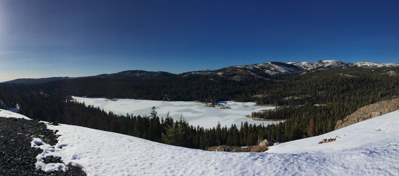 |
| Lake Alpine (frozen) from Inspiration Point |
Ebbetts pass, about halfway between Yosemite and Lake Tahoe, may be the most forgotten high pass in the Sierra Nevada. The peaks in this area aren't quite as prominent as their neighbors to the north and south and the one ski resort in the area is less developed than the sprawling sports villages around Tahoe. As a result this area has a quiet, out of the way feel. Lake Alpine is the hub of activity in this area during the summer, with several campgrounds and resort that rents out canoes and paddle-boards. This short hike climbs a small prominence above the lake for a great view of the rolling slopes of the Stanislaus National Forest to the south, the Pacific Crest to the east and Lake Alpine to the northwest.
2.5 miles RT with about 600 feet of climb.
Best visited June - September
Note also that Calaveras Big Trees State Park, one of the better spots for hiking through Giant Sequoias is 30 min west of Lake Alpine on CA highway 4. Dogs aren't allowed on the trails at Big Trees, but if you've got multiple humans with you and some dogs that you've already tired out at the lake, then it's probably worth taking turns popping into the North Grove for 30 mins while someone watches the dogs at the car.
5. Old Ski Bowl on Mt Shasta
 |
| The trailhead at the Old Ski Bowl |
In the 1950s a downhill ski park operated high on the slopes of Mt Shasta, well above the elevation of the current Mt. Shasta Ski Park. Combustable lodges and avalanche-prone ski lifts ended that enterprise, but the history of development kept this slice of the mountain outside the Mt Shasta Wilderness, which bans dogs on trails. The entire area is above the tree line, so you get sweeping views of the Summit above and Trinity Alps to the southwest right out of the car. You can make a short outing up into the bowl or keep climbing all the way up to Green Butte, the thousand foot prominence that looms over the trailhead.
Milage/climb is pretty arbitrary, after about 2 miles and 1500 feet of climb, you run out of dirt road. A trip out to the top of Green Butte would be about 5 miles round trip with about 1700 feet of climb.
Best visited June - September.
6. Winnemucca Lake (Carson Pass)
 |
| Lake Winnemucca from the base of Mt Roundtop. Carson Pass behind. |
Carson Pass is one of the highest Sierra highway passes maintained year round. This hike climbs gently to a scenic lake in the shadow of craggy Mt Roundtop. The sparse tree cover along the way affords plenty of views of the surrounding peaks.
2 miles RT, with 200 feet of climb to Frog Pond
5 miles RT, with 400 feet of climb to Winnemucca Lake
7 miles RT, with 800 feet of climb to Round Top Lake
8 miles RT, with 1700 feet of climb to the top of Round Top
(This last section is very strenuous, maybe not appropriate for most dogs)
Best to visit June - September. Higher elevations likely won't be snow free until July.
7. Castle Lake to Heart Lake (Near the city of Mt. Shasta)
 |
| Castle Lake from near Heart Lake. Black Butte rises above the town of Mt Shasta in the distance. |
Castle Lake is a scenic alpine lake near Mt. Shasta that can be explored with a very short walk from the parking area. A light hike up to Heart Lake and the surrounding ridges yields some nice views of Castle Lake, Mt. Shasta and the Trinity Alps.
About half a mile, with no climb if you take the trail along the west side of the lake.
About 2 miles RT, with about 500 feet of climb to Heart Lake
About 3 miles RT, with about 1000 feet of climb to the minor peak above Heart Lake
10 miles RT to the Mt Bradley lookout along Castle Lake Trail. No net climb on that hike but lots of up and down for a couple thousand feet of total climbing
Best visited May - July depending on snow conditions. Because of their lower elevation, the Trinities usually lose their snow earlier than the Sierra and can get really hot in late summer.
8. Redwood Regional Park (Oakland)
 |
| Some of the larger redwoods at Redwood Regional Park |
About 0.25 miles on a paved path to the first shady groves of redwoods
About 1.5 miles of gently climbing paved path and wide dirt path along the redwood creek
5 mile loop of consistent shade, with 500 feet of climb on a loop out the Stream Trail and back on the French Trail
8 mile loop, with 1000 feet of climb out the Stream Trail and back via the West Ridge Trail.
Nice to visit year round. Can be especially pleasant on warm summer days.
9. Cataract Creek Trail (Marin)
 |
| One of several small cascades on Cataract Creek |
Less than 0.5 miles to the first set of falls, with less than 200 feet of climb
About 1.25 miles, with about 800 feet of climb to the highest set of cascades
About 4.5 miles RT, with about 1300 feet of climb to Twin Knolls.
Best visited January - April soon after some decent rain to get the falls running.
10. Rodeo Beach and Wolf Ridge (Marin)
 |
| Looking back at Rodeo Beach from the shoulder of Wolf Ridge. |
With so many miles of rugged coastline, you'd think it would be easy to find great dog-friendly hikes with ocean views in California, but it's surprisingly hard. There are a few dog-friendly beaches strung along the coast from Point Reyes to Monterrey, but mostly these are small isolated beaches without any hiking nearby. Rodeo Beach in the Golden Gate National Recreation Area is an exception to this, with a very scenic hike open to dogs directly from the beach. The Wolf Ridge loop climbs over old military bunkers and observation posts perched on the hills above, offering great views of the ocean and the Marin headlands. Climb up to to the first set of bunkers for a light outing or keeping going around the whole loop for a five mile hike with a bit under a thousand feet of climb.
1 mile RT, with 300 feet of climb to the old bunker and artillery tube.
3 miles RT, with 800 feet of climb to the top of Wolf Ridge.
5 mile loop, with maybe 850 feet of climb around the Wolf Ridge loop.
Best visited any time of year, just check the local forecast for fog and drizzle that might not be apparent from your house.
11. Oat Hill Mine Trail (Napa Valley)
 |
| The first viewpoint of Napa Valley from Oat Hill Mine Trail |
1 mile RT, 200 feet of climb to first bench.
About 4 miles RT, with 1000 feet of climb to a great rocky overlook below bald hill
Up to 8 miles RT with 2000 feet of climb to Duff Benchmark
Best visited February - May when the grass is green and the grapes are growing.
12. Sunset Drive and 17 Mile Drive (Monterey Peninsula)
 |
| The dunes around Asilomar State Beach |
Up to 14 miles RT, no appreciable elevation gain.
Best visited year round.
Strenuous Hikes
Dayhikes, strenuous trail runs, and short backpacking trips to tire humans and dogs alike
1. John Muir Trail in the Ansel Adams Wilderness (Mammoth Lakes)
 |
| Banner Peak reflected in Thousand Island Lake |
Milage will vary. Thousand Island Lake from Agnew Meadows via Shadow and Garnett Lakes was 9 miles one way, with about 2,600 feet of climb.
Best visited July - October.
2. Mt Tallac (South Lake Tahoe)
 |
| The summit panorama from Mt Tallac |
This hike is all about the summit. Mt. Tallac towers 3,000 feet over the southwest corner of Lake Tahoe. The rocky peak offers fantastic views of Emerald Bay, Fallen Leaf Lake, and the higher peaks of the Desolation Wilderness to the northwest. One of the finest views anywhere.
8.5 miles RT, with about 3,200 feet of climb
Best visited July - November.
3. The Lost Coast (between Fort Bragg and Eureka)
 |
| Black Sands Beach on the Lost Coast |
One of the few large swaths of California coast open to dogs is also one of the most pristine and beautiful. For over 20 miles north of Shelter Cove, a primitive trail follows the beach at the base of the King Range, which abruptly rises 2,000 feet in the first mile inland from the beach. The steep terrain creates several stretches of narrow beach that are only traversable at low tide. Thus, one must plan a trip along the coast with the tide table in mind and find campsites in the isolated creek outlets and pockets of raised bluffs. This all lends towards a satisfying level adventure and isolation amongst dramatic scenery.
Milage will vary, but our trip was 8.5 miles one way from Shelter Cove to Big Flat, then 11 miles RT with 3500 feet of climb to the main ridge of the king range. Summiting King Peak would be about 16 miles RT and 4000 feet of climb from Big Flat.
I'm not actually sure the best time to visit. Depending on rain it could be quite nice in the fall and spring, but summer is probably the only time you can plan on not getting a lot of cold grey drizzle.
4. Canyon Creek Lakes (Weaverville)
 |
| Canyon Creek Lakes with Sawtooth Mountain behind. |
The Trinity Alps are an under appreciated mountain range on the western side of the far northern terminus of California's central valley. The Trinities have all the prominence of the Sierra, but at a lower altitude and generally more water and vegetation. The trail up Canyon Creek to the Canyon Creek Lakes is arguably the marquee hike of the range. The lakes can be reached in a very long day hike (20 miles) or more comfortably as an overnight backpacking trip, with options to explore higher areas off maintained trails beyond the lakes. The canyon its self is very scenic with some nice views of surrounding ridges and a few small waterfalls peppered along the route, so it's worth a visit even if you can't make it all the way to the lakes.
First significant falls: 7 miles RT, with about 1500 feet of climb
Lower Canyon Creek Lake: 16 miles RT, with about 2600 feet of climb.
Upper Canyon Creek Lake: 18 miles RT, with about 2700 feet of climb.
Best visited May - July depending on snow conditions. Because of their lower elevation, the Trinities usually lose their snow earlier than the Sierra and can get really hot in late summer.
5. Kaiser Peak via College Rock (Huntington Lake Area)
 |
| College Rock overlooking Huntington Lake |
College Rock: 5 miles RT, with about 1500 feet of climb.
Kaiser Peak: 10 miles RT, with about 3000 feet of climb.
Best visited June - November.
6. Leavitt Peak (Sonora Pass)
 |
| The scree-covered summit of Leavitt Peak |
The first high pass over the Sierra north of Yosemite is Sonora Pass, second only to Tioga Pass among Sierra passes in terms of both elevation and scenery. And that with about 1/100th the annual visitors as Tioga Pass (that's just my estimate, but seriously that's not hyperbole). Hiking south from the trailhead at the height of the pass, the Pacific Crest Trail passes just under the summit of Leavitt Peak, which can be reached by a technically easy use trail or some cross-country rambling over the rocky moonscape. The peak provides excellent views into the high country of Yosemite. Topping out at 11,500 feet, this hike is at about the limit of what my body can take when driving up from sea level on hike day.
11 miles RT, with about 2,000 feet of climb.
Best visited July - October.
11 miles RT, with about 2,000 feet of climb.
Best visited July - October.
7. Granite Lake (Weaverville)
 |
| Granite Lake |
Granite Lake is another idyllic alpine lake in the Trinity Alps. The hike in follows a the appropriately named Swift Creek, then its tributary Granite Creek with a few small waterfalls as cascades along the way. The Granite Lake isn't overshadowed by ridges and peaks as impressive as the more crowded Canyon Creek Lakes, but it's ringed by some nice granite cliffs nonetheless. It's a perfect swimming hole and easily reached as a 10 mile day-hike or could be included in a several options for longer backpacking trips.
10 miles RT to Granite Lake, with 2,000 feet of climb.
Add 3 miles and another 1,500 feet of climb to reach the pass below Seven Up Peak.
Best visited May - July depending on snow conditions. Because of their lower elevation, the Trinities usually lose their snow earlier than the Sierra and can get really hot in late summer.
8. John Muir Trail in the John Muir Wilderness (Huntington Lake Area)
 |
| Lake Marie on on the JMT/PCT (elevation 10,600 feet) |
Milage will vary, but the loop from Florence Lake to Edison Lake described above (the shortest reasonable point to point, really) was 25 miles with about 4,000 feet of total climb.
Best visited July to October. High elevations mean the snow lasts well into early summer and comes early in the fall.
9. Ralston Peak (Desolation Wilderness)
 |
| Ralston Peak, overlooking Ralston Lake, Tamarack Lake and Upper Echo Lake in the Desolation Wilderness |
7 miles RT, with about 2,800 feet of climb.
Best visited May to November depending on snow conditions. Slightly lower elevations and a south-west facing approach mean this route is often snow-free a few weeks before many nearby peaks.
10. Mt Tamalpais Fire Roads (Marin)
 |
| Looking south from the Old Railroad Grade fire road on Mt Tamalpais. The Pacific Ocean, the Marin Headlands, and the San Fransisco Bay are visible in the distance. |
The trails in Mt. Tamalpais State Park are off limits to dogs. Weirdly though, most of the mountain isn't actually in the state park. The entire upper half of the mountain (except for a tiny strip along the top) is under the management of the Marin Municipal Water district. Fire roads and hiking trails in these sections are open to dogs on leash, as well as the short trail to the summit fire tower. This road/trail network is good a light hike and the moderated grades are great for trail runs with big steady climbs. My favorite place to start a trail run on these roads is at the base of the old railroad grade at the end of Fern Canyon Road in Mill Valley. From here you can take a 5 mile trip out to West Point Inn and back, or an 8 mile loop that passes over the main crest of the mountain. There are several great views of the San Fransisco Bay on the way to the West Point Inn, and a few nice views north into Marin can be had on the descent down the north side of the peak. If you're up for a truly epic day, you could start from a number of lower trailheads as well and easily route a half or full marathon on dirt roads with a couple thousand feet of elevation gain.
5 miles RT with about 600 feet of climb to West Point Inn
8 mile loop with about 2200 feet of climb over the summit and down the north side
A good option year round.
5 miles RT with about 600 feet of climb to West Point Inn
8 mile loop with about 2200 feet of climb over the summit and down the north side
A good option year round.
11. Mt Montara (Pacifica)
 |
| Watching for grey whales from the trail up Mt. Montara, with Montora State Beach visible below. |
Montara State Beach is a dog friendly beach just south of Pacifica on the San Francisco peninsula. It's near some classic California coastal cliffs and it's popular spot for watching the annual Gray Whale migration up and down the coast. Just across highway 1 from the beach is McNee Ranch State Park, which includes the 1900 foot Mt Montara. This the best dog-friendly beach/mountain combination hike from the same trailhead that I've found in California outside The Lost Coast. The two radio-towered summits of the mountain are somewhat anticlimactic, but there are several great views from the trail on the ascent looking south down the coast and northeast into the San Fransisco Bay.
9 miles, 1900 feet of climb to the summit.
Best visited in January or March when the gray whale migration is at its peak.
12. Sunol Wilderness (Sunol)
 |
| Grassy hills with a smattering of oak in the Sunol Regional "Wilderness" |
The grassy rolling hills guarding the eastern approaches to the San Fransisco Bay are peppered with parks that are more dog friendly than most in the bay area. Generally, hikes in these parks just aren't in the same league as hikes in the Sierra Nevada, the Trinity Alps, or directly on the coast. They are easy to reach, though, and provide lots of options for quad-burning hikes and trail runs to get in shape for the mountains. Grazing of cattle on these parks keeps them open and sparsely treed, which translates into unpleasant sun exposure and dusty trails, through a sea of dead grass in the summer. In the late winter and spring however, fresh green shoots blanked the hills and the open vistas are really very pleasant. My favorite of these parks is the Sunol Wilderness, situated just over Mission Peak from Freemont, CA. Sunol has a good combination of steep, grassy peaks with views, some shady oak woods and a pleasant stream running through the valley to give it a bit more variety than the other east bay cow parks.
High Point Loop: 10 miles with 2000 feet of climb
Indian Joe Cutoff: 7 miles with 1600 feet of climb
Canyon View Cutoff: 3 miles with 400 feet of climb
Best visited in February to May when the grass is green and breezes are cool.
The few hikes worth doing without your dog
Hike or run a few of the trails above and you'll see there's no need to leave your dog at home when exploring California. But sometimes you find yourself with a weekend when for whatever reason, you're dogless. On such occasions you should go see the very short list of places in California that can't be reproduced with dog-friendly alternatives.
1. Half Dome -OR- Clouds Rest (Yosemite National Park)
MUST SEE
 |
| Half Dome and Yosemite Valley as viewed from the summit of Cloud's Rest |
If you find yourself out of luck, drive up Tioga Pass road to Lake Tenaya and hike to the summit of Cloud's Rest. Only an 12 mile hike with about 3,000 feet of elevation gain, Cloud's Rest has a fantastic rocky summit overlooking Half Dome and the valley below, as well as a magnificent section of the Pacific Crest to the east. This is quite possibly my favorite summit of all time.
Best visited June - October
2. Mist Trail to Nevada Falls -OR- Yosemite Falls Trail (Yosemite National Park)
MUST SEE
 |
| Yosemite Falls |
If you get a chance to hike Half Dome, then you'll hike past the excellent Vernal Falls and Nevada Falls on the way. These falls are my favorite in the park. If you've already made it up Half Dome, though, Yosemite Falls are excellent too.
Yosemite Falls via Yosemite Falls Trail: 6 miles RT, 3000 feet of climb.
Nevada Falls via Mist Trail: 5.4 miles RT, 2000 feet of climb.
Vernal Falls via Mist Trail: 2.4 miles RT, 1000 feet of climb.
Best visited May - July when the falls are flowing highest.
Yosemite Falls via Yosemite Falls Trail: 6 miles RT, 3000 feet of climb.
Nevada Falls via Mist Trail: 5.4 miles RT, 2000 feet of climb.
Vernal Falls via Mist Trail: 2.4 miles RT, 1000 feet of climb.
Best visited May - July when the falls are flowing highest.
3. At least one marquee grove of coastal redwoods
MUST SEE
 |
| Big Basin Redwoods |
There's nothing quite like a walk through the natural cathedrals of California's coastal redwoods, the tallest trees in the world. There are a few less-mature forests that are open to dogs (my favorites are Redwoods Regional Park in Oakland and Mt. Modonna County Park near Santa Cruz) but they just aren't as special as top tier groves. The most accessible mature groves from northern California population centers are Muir Woods National Monument in Marin and Big Basin Redwoods State Park north of Santa Cruz, which I found roughly equivalent in terms of treely awesomeness. Muir Woods is a better overall destination though, because you can combine a walk through the fairly compact mature grove with a hike up to the summit of Mt. Tamalpais, or to the Pantoll Ranger Station and the western ridge of the mountain with excellent views overlooking the Pacific Ocean. Muir Woods is also near Muir Beach, where dogs are allowed. Redwoods National and State Parks, way up in Humbolt County offer the most extensive collection of mature redwoods, but they are a very long drive from any highly populated place. There are a few nice spots you can bring dogs in these parks, including some very nice campgrounds, but dogs are banned on all trails.
Equally nice to visit year round.
Equally nice to visit year round.
4. At least one marquee grove of giant sequoias
MUST SEE
After you've visited the tallest trees in the word, you should go visit the most massive trees. A bit shorter and stouter than their coastal relatives, the giant sequoias of the Sierra Nevada are also an absolute must-see. The Mariposa Grove in the southern cornerYosemite National Park is generally considered the best, but Calaveras Big Trees State Park (on CA Highway 4 below Ebbetts pass) is also very nice and more easily reached from the SF Bay Area or Sacramento. Calaveras Big Trees also has the advantage of hosting a very mature grove very close to the highway and being near lots of dog-friendly hiking. Thus, a group out with dogs for the day can work in a quick visit to at least one mature grove while taking turns watching the dogs, then continue on to Lake Alpine or Ebbetts Pass for more outdoor fun together.
There are a couple of lesser groves of giant sequoia open to dogs too. Placer County Grove south of I80 and Nelder Grove near Oakhurst, CA each have just a handful of big trees. They are both worth a visit if you find yourself near them, but neither is an adequate substitute for Big Trees or Mariposa.
Equally nice to visit year round, though winter weather may make driving a challenge to some groves.
5. Cinder Cone and the Painted Dunes (Lassen National Park)
Worth a visit if convenient
 |
| The painted dunes from the Cinder Cone |
Lassen National Park is plenty nice all around, but the main peak and most of the park are no more majestic than any number of Sierra peaks and national forests and so not worth leaving your dog at home for. The geologic oddities of the park make it worth a visit though. On the north side of the park, there is a very unique hike up an extinct cinder cone volcano. You ascend a nearly perfect 800 foot cone of cinders to a 360-degree view including a wide plain of jagged volcanic flows and rolling hills accented with red pumice fields. Also, near the trailhead to the short hike up the main peak is a short walk to the bubbling sulfur pits of Bumpass Hell. It's no Yellowstone, but it's the most dependable and interesting hydrothermal attraction I've seen in California. You can pop in to see it on easy, 3 mile hike round trip, so it makes a nice add-on trip after or before a more substantial hike.
Cinder Cone Summit: 4 miles RT, 850 feet of climb.
Bumpass Hell: 3 miles RT, 300 feet descent and back climb.
Lassen Peak: 5 miles RT, 2000 feet elevation gain.
Best visited June - October
Cinder Cone Summit: 4 miles RT, 850 feet of climb.
Bumpass Hell: 3 miles RT, 300 feet descent and back climb.
Lassen Peak: 5 miles RT, 2000 feet elevation gain.
Best visited June - October
6. Bear Gulch Cave, Balconies Cave and High Peaks (Pinnacles National Park)
Worth a visit if convenient
 |
The bouldery ceiling of Bear Gulch Cave
|
In the hills between Monterrey and the central valley, Pinnacles National Park is an oft-overlooked place. There is a fun trail over some rocky peaks with several sections of stairs, railings, and ledges to liven up the hike, but what really makes the hike special are the two sections of caves formed by boulders piling over narrow canyons. Be sure to check the park website ahead of a trip though, as the caves are closed for long periods to protect the resident bat colonies during breeding season.
Bear Gulch Cave, High Peaks and Balconies Cave: 10 miles, with 1700 feet of climb.
Bear Gulch Cave, High Peaks and Condor Gulch: 5.5 miles, with 1600 feet of climb.
Best visited in March or October when the caves are usually open.
Bear Gulch Cave, High Peaks and Balconies Cave: 10 miles, with 1700 feet of climb.
Bear Gulch Cave, High Peaks and Condor Gulch: 5.5 miles, with 1600 feet of climb.
Best visited in March or October when the caves are usually open.
7. Mt Shasta Summit
 |
| Looking toward the Mt Shasta summit from the top of the old Ski Bowl |
Mt Shasta is a freaking huge mountain. The southern-most in the chain of isolated, behemoth volcanoes of the Cascade Range stretching up to Mt Rainer, this peak is officially the second most prominent spot in California, after Mt Whitney. Given that there is nothing of remotely similar elevation for hundreds of miles though, it feels utterly more singular than the high peaks of the southern Sierra. I have yet to make a trip to the summit, where dogs are banned above 10,000 feet, but it's on the bucket list.
No comments:
Post a Comment