Near: Weaverville
Trip Type: Day Hike
Distance: 18 miles
Elevation: 3,100 - 5,800 ft
Vegetation: Pine Forest
Last Visit: 6/5/2016

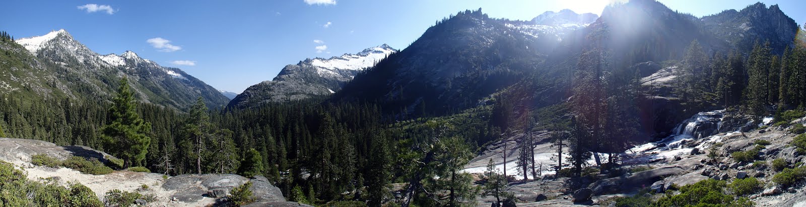
After a long Memorial Day weekend in the Trinity Alps, they've cemented their place as my favorite place in California. Yosemite is more draw dropping, but of course you can't hike with your dog there. The valleys in the Trinities are lower, and rain more plentiful, yielding a healthier, more vibrant ecology swimming with alpine lakes and streams. Canyon Creek Lakes are the headliner hikes for the Trinities for good reason. The trail is a straight shot up the a dramatic canyon with peaks towering 4,000 feet above you at points. The canyon is dotted with more than a half dozen scenic waterfalls and ends in two fantastic alpine lakes.
The only real negative about this hike is its over-popularity for backpacking. There are no entry quotas in place in the Trinity Alps Wilderness, so very popular routes like this one get overcrowded on holiday weekends. When we visited many backpacking groups were camping too close to the trail and stream and acting a bit passive agressive on the trail trying to send out their fastest hikers to claim choice campsites. Maybe it's best if things are kept this way on this trail, though, because seeing it stopped me complaining about entry quotas elsewhere.
At 18 miles round trip, a day hike to the upper lake is long, but very doable for avid hikers. There's nearly 3,000 feet of elevation gain, but it's a steady ascent with very little back-climbing. The trail is mostly very easy to follow so you can make good time. We made the round trip in 7 hours. If that still sounds like a bit of a death march to you, then you should still consider heading up the trail for a shorter hike. Starting about 3 miles in, there are sweeping views and waterfalls aplenty at regular intervals all the way up the valley. Even without making the lakes, it's still a great hike.
Rules:
This hike is in the Trinity Alps Wilderness, part of the Shasta-Trinity national forest. Wilderness permits are required for camping, but there is no entry quota as of this writing in winter 2019. No permits are required for day hikers. Bear canisters are recommended for campers but not explicitly required. Dogs are OK off leash under effective voice control.
Trailhead:
At the end of Canyon Creek Road, which leaves CA-299 at Junction City, across from a shabby looking general store. You drive up this long windy road overlooking a beautiful stream for almost a half hour, seeing no traffic at all, then BAM! PACKED parking lot. Get here early to avoid the scrum for spots.
Ripstein Campground
Just a note here about a lovely campground near the trailhead. Ripstein campground is on Canyon Creek Rd. Less than a mile before the trailhead. This site has no running water, so be sure to bring plenty of your own and/or a filter. But it's very shady and peaceful, with the rushing water of Canyon Creek to lull you to sleep. Several campsites are on a small bluff directly over the creek. Some friends who braved the backpacking scene here used the campsite as most do, arriving at 2AM Friday night, finding it full and camping along the road... BUT when we arrived at noon on Saturday, there were several open spots and we grabbed one before we hit the trail. So when we rolled off our death march, we just popped back down to Ripstein, took a quick hiker's shower in a calm spot in Canyon Creek and slept the sleep of the just. It doesn't seem right that this campground is free. I would gladly pay a nominal fee to support it.
 |
| Our spot at Ripstein |
 |
| Another site just above the creek. |
 |
| Canyon Creek, steps from the Ripstein Campground |
Route:
Caltopo Map: http://caltopo.com/m/SQGA

Note: Caltopo suggests this route is about 15mi round trip, but trailside signs said it was 8 miles to Lower Canyon Creek Lake, making the round trip to the upper lake 17-18 miles. In general, the Caltopo distance estimates should be regarded as a minimum estimate, since they rarely capture every twist and turn of the trail, but they seem to be especially low for this trail.


Soon after, the trail emerges onto the side of a steep slope with less cover, opening up stunning views of the valley.

Between 3 and 4 miles in, you get a view across to a set of cascades dropping 3,000 feet down to the valley floor. From this spot you can just also just see a few glimpses of the first major waterfall on Canyon Creek through the trees below.

Around 4 miles in, the trail passes a lovely set of falls (though small for this hike). Perfect for a snack. From this point, the trail pretty much alternates between scenic cascades and falls, vista's back down the valley and the occasional meadow all the way up to the lakes.
 |
| The first of many idyllic trail-side waterfalls. |


About 7 miles in, just before the final climb to the lakes, the stream crosses to the west side of Canyon Creek. Probably in late summer this is an easy crossing, but with all the late spring meltwater it was a bit tricky for us. There as nice bridge of logs to cross on, but on the way back we opted to take our shoes off and wade rather than risk a jump to slippery log. It wasn't really bad at all, just be ready for some cold feet.
 |
| Tricky stream crossing below the upper falls. |
 |
| Last falls below the lakes. |
 |
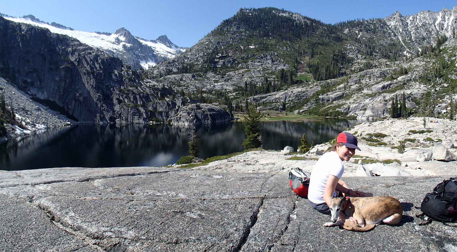
| Lower Canyon Creek Lake |
The trail is less maintained here, but small cairns mark the way.
 |
| Climbing along the western slopes of Lower Canyon Creek Lake. |
The trail proper ends on a high isthmus between the upper and lower lakes and that's were we decided we'd had enough. Backpackers and those up for a truly epic day hike continue along faint use trails around the east side of the upper lake and northeast up a stream leading to L lake in the shadow of Sawtooth ridge.
Because we started at 1PM, we had to hustle to beat nightfall down the canyon, but we were treated to some lovely evening light on the way down.
 |
| Upper Canyon Creek Meadow, just before sunset. |
 |
| The last rays of sun graze a tall tree on the ridge above us as we leave the open vistas for good. |
I love it! It sounds pretty spectacular especially since you've seen a lot of Alpine beauties. Am excited to backpack it one day and will pay attention to your tips!
ReplyDeleteI love it! It sounds pretty spectacular especially since you've seen a lot of Alpine beauties. Am excited to backpack it one day and will pay attention to your tips!
ReplyDelete