Near: South Lake Tahoe
Trip Type: Day Hike
Length: 16 Miles
Elevation: 6,600 - 10,000 ft
Vegetation: Pine Forest to Moonscape
Surface: Mostly dirt to Dick's Pass, Rock and Scree to Dick's Peak
Last Visit: 7/23/16

Dicks Peak is the highest point in the Desolation Wilderness or anywhere on the west side of Lake Tahoe. Best hiked as an overnight or long day hike from trailheads on Emerald Bay or Fallen Leaf Lake. It's a long haul for a day hike as we did it, but our route offers several options for shorter turnaround points at Eagle lake (2 miles, round trip), an overlook (4 miles), Dick's Lake (8 miles), or Dick's Pass (12 miles). Be warned, though, the final ascent requires some rocky scrambling that's no trouble for most primates, but will beyond many dog/human combinations. Don't attempt the summit unless your dog is relatively spry and obedient, and you're confident you can hoist them down a few 4-foot drops on the descent. If that sounds fine and you enjoy a little scrambling and a great view, Dick's Peak makes for a very satisfying summit.
Permits
Free day-use permits are required in the Desolation Wilderness. Use the permit station at the trailhead to sign in. If you want to camp, you'll need an overnight permit. The Desolation Wilderness is sectioned off into several zones with entry quotas, so these permits can be difficult to get a hold of on summer weekends. 70% of the permits are available for reservation on
Recreation.gov. The remainder can be claimed on the day of entry at the Pacific Ranger District (near Pollock Pines on Hwy 50) or the Lake Tahoe Visitor Center (South Lake Tahoe).
Trailhead:
The Eagle Falls Trailhead, (or Bayview Campground) on Hwy 89 above Emerald Bay. Most likely on a weekend you'll actually need to park on the road between these two points. The crowds around Eagle Falls can be off-putting, but they disperse rapidly on the trail. After Eagle Lake, we only saw about 20 people spread out over the whole (long) day. Note if you plan to spend the night in the Wilderness, you'll need a permit. The Desolation Wilderness is supposedly one of the most visited wilderness areas in the country and overnight permits have strict quotas, so camping on a weekend often requires several months of advance planning.

Route
Caltopo:
http://caltopo.com/m/Q1JQ


Our route started at a Eagle Falls. The whole Emerald Bay area is extremely popular and Eagle Falls are an easily accessible family hike, so boy was it crowded on a July Saturday. It was a conga-line to the bridge over the upper falls about a quarter mile in.
 |
| Bridge over Upper Eagle Falls |
Just past the bridge, you enter the Wilderness area, and the crowd gets more manageable.
 |
| Entering the Desolation Wilderness |
A mile in, a fork in the trail leads to Eagle Lake. Most the traffic breaks right to swim and fish at the lake, we stayed left to start climbing above the lake on the suddenly more peaceful trail.
 |
| Eagle Lake |
About 2 miles in the trail passes by a few rocky ledges to right overlooking Eagle Lake, with Maggies Peak North.
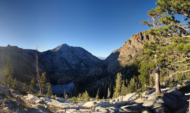
Around 3 miles in, the trail meets the Granite Lake Trail heading over Maggies Peaks from Bayview Campground. The climb stops here and the trail rolls across nearly level, sparsely treed terrain.

After another intersection with the Velma Lakes trail (a nice destination on their own), the trail crosses a shallow valley and begins climbing again towards Dicks Lake.
 |
| Looking back over the Velma Lakes Basin near Dicks Lake |
After this brief climb, the Granite Lake Trail ends with an intersection with the PCT. Heading north here would take you to nearby Fontanillis Lake, then down to the Velma Lakes, from which you could loop back to the Granite Lake Trail and return to Eagle Falls or Bayview. At the PCT we met a woman out for a serious trail run making that loop. I was impressed by the giant stick here dog insisted on carrying for miles and miles.
 |
| Respect |
You would also head north on the PCT here if you wanted to head down to Dick's Lake. We headed south though, and began our climb towards the Dicks Pass. As we climbed, Dick's Lake came into view under the slopes of Dick's Peak. The north or east shores of the lake look like a fantastic overnight spot. If you choose to do the peak as a backpacking trip camping here or at Fonanillis Lake is the obvious choice. If you do that, make sure to check out the cascades between Fontanillis Lake and Upper Velma Lake.
 |
| Dick's Lake, with Dick's Peak behind. |
We stopped for lunch at shady spot of Dick's Lake, just switchbacks up the pass got going. Presto thought it was time for nap.


 |
| Dick's Peak, a bit higher up the PCT |
Once you crest the pass views open up to the north over half-moon lake and some limited views of Lake Aloha. Oddly, enough Dick's "Pass" is not the lowest point on the ridge, so you descend a bit to the true pass on the PCT from here.

At the true pass, a use trail veers off onto the ridge. The trail is a bit hard to follow at points as you traverse the ridge just south of a minor peak, but it's obvious where you're going. The minor peak here is a great place to stop and declare victory if your dog isn't ready for some rocky scrambling and loose scree. Just beyond is the short tricky section pictured below. A use trail leads up the bottom section of the false summit ahead, then divides. It seemed like a human could take this a number of ways without much trouble. We found the only way Presto could do it on his own was to make for the scree shoot just to the south of the ridge line, and keep right on the solid rock bordering it. That made for the most gentle ramp.

 |
| Scrambling up the false summit. |
 |
| Presto takes a rest behind a boulder while we wait for some other hikers to descend the scree shoot. Watch for falling rock in this area. |
 |
| Looking up the top of the scree shoot. Near the top it get's a bit steeper. |
 |
| At the top of the scree shoot, we crossed to the left side and around some small trees. |
Once atop the false summit, it's an easy ridge-walk to the peak.
 |
| Looking east to the peak from the false summit. |
 |
| Looking back over Dick's Lake, with Lake Tahoe in the distance. |
 |
| The final ascent. |
 |
| Summit! What a view. |
We would have preferred to linger longer, but we only stayed briefly at the summit. We'd taken until after 4pm to get there and we had a long way back... We made back to Eagle Falls just after sundown. This is a good hike to attempt mid-summer with lots of daylight to work with.
 |
| Sunset on the west face of Maggie's Peak North. |
 |
| Emerald Bay at Sunset. |


No comments:
Post a Comment