Near: Fresno
Distance: 12 miles
Elevation: 7500 - 9000 feet
Vegetation: Pine forest
Last Visit: July 2020

**Note: the Ansel Adams Wilderness was heavily impacted by the Creek Fire of 2020. Check the
Sierra National Forest website for up to date information on trail closures.**
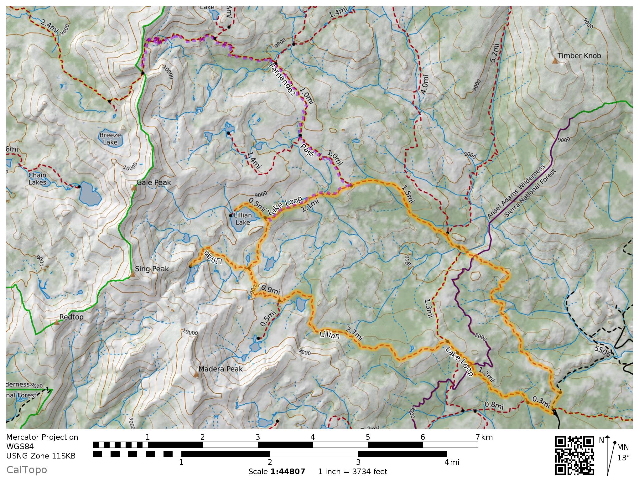
You really can't go wrong in the Ansel Adams Wilderness. We usually access the Ansel Adams from the Bishop side of the Pacific Crest, but there's a huge chunk of it more easily accessed from the Fresno side. I'd been eyeing a trip into this area for a while when wildfires pushed us off our planned route and some calling around turned up the last two open spots on the quota from the Fernandez trailhead on the Lillian Lake Loop. We were quite pleased with our 'misfortune'. This loop is doable as a day hike but makes for a nice moderate backpacking loop too. The loop passes directly by two excellent alpine lakes and close enough for short side trips to three more. While the loop doesn't hit any peaks or high passes, several spots along the trail afford wide views to the northwest. I highly recommend making the detour to Chittenden Lake as the lake is very nice and the rocky benches on it's southern side afford the best views of the hike. The best camp sites are around Lillian Lake, which also makes a convenient staging area for day hike to Rutherford Lake and/or Fernandez Pass to the north.
Rules
This route is in the Ansel Adams Wilderness. No permits are required for a day use, but overnight trips require a wilderness permit from the Sierra National Forest. You have to call or write in for these permits as the Sierra National Forest does not list these permits on Recreation.gov like most national forests. Note that there are two different set of quotas for the Fernandez Trail (the southern arm of the loop) or the Walton Trail (the northern arm of the loop) so if one's full up make sure to ask about the other. Dogs OK off leash if under voice control. As always voice control means they won't go chasing random wildlife and get lost or attack an animal. We saw half a dozen marmots on the trail and there are lots of bears in the area.
Trailhead
The Fernandez trailhead on National Forest Road 5S05 off of Beasore Road. This trailhead can be quite an adventure to get to. As of July 2020 google maps didn't have 5S05 mapped quite correctly. The intersection you want is about half way between Bowler Group Camp and Norris Creek on Beasore Road and is clearly signed. Beasore Road is a very very long winding road up from the Bass Lake area and goes from good condition, to very pot-holed to more pot-hole than road before mercifully turning to just dirt for the last section. Perfectly doable by our Prius but low clearance cars will need to drive carefully at points. Also not that google maps and cell service are spotty for much of the drive. Make sure to check the
National Forest Service website for road conditions. If I'd done that ahead of time I might have been psychologically prepared for the massive detour required due to a closure of a bridge along the way... That said, this is one of the most scenic roads in the Sierra I've ever driven on. Sweeping views over Yosemiteseque granite domes abound.
Route Notes
The route is a pretty straightforward loop. Either direction seems equally good if you're making the full loop. If you aren't sure you'll make it around definitely go for the southern arm via Vandenburg Lake as there are more options for particularly nice scenery before Lillian Lake. The northern arm has a few nice views to the north east along the way, but that's it. Chittenden lake is the coolest lake we visited with the nicest views too, but we didn't make it to the Madera Lakes (sign for Lady Lake on the trail) so they could be pretty good too. The spur to Chittenden is a bit more sparse and requires more attention to follow then the rest of the loop, but we had one 30 second episode of 'uh... where's the trail?' on the way up. Lillian lake has the best camping spots on the north side of the lake (a bout a dozen large, obvious sites many with fire rings) and is the only lake you're allowed to have a fire at.
The side trip we took up to Fernandez Pass is a bit of a slog with some up and down, but the views at the pass are excellent with a great vantage on the Minerets and some of the high peaks of Yosemite to the north. The unnamed peak directly west of the pass is pretty easy for a human to scramble up, but the top is a jumbly ridge of large boulders that are very tiring for humans and really not doable by most dogs. The view is slightly better than the pass if you can get onto the lower stretch of the boulders though, up an easy sandy climb through the sparse trees.
Photos
 |
| The trailhead |
 |
| A
view north to the Minerets from the Walton Trail. An afternoon thunder
shower was building over us. About 10 minutes later we got hailed on
for about 30 minutes... |
 |
| More storms brewing over Sing Peak from Lillian Lake |
 |
| Hanging out on the unnamed peak west of Fernandez Pass |
 |
| Remains of a lightning strike on Fernandez Pass |
 |
| The
view from Fernandez Pass. I was all excited to get the view into
Yosemite from the pass, but the view over the Ansel Adams was actually
better. |
 |
| Coming back down a section near Fernandez Pass |
 |
| Lots of little pocket meadows like this one near Chittenden Lake on the loop. |
 |
| The
thunderstorms left Presto lots of little water stops. There are a few
reliable streams for water stops but some sections of the trail are very
dry, so make sure your dog is getting enough water. |
 |
| The view from the rocks above Chittenden Lake. Almost as good as from Fernandez Pass. |
 |
| Panorama with Chittenden Lake in the background. I should have taken more pictures of Chittenden lake |
 |
| Sparse trail markings on the rocky slabs leading to Chittenden Lake |
 |
| Vanderburg Lake |
 |
| One of the last nice views as we dropped over a rocky slope on our way back to the trailhead from Vanderburg Lake. |


No comments:
Post a Comment