Saturday, November 19, 2016
White Hill
Near: Fairfax
White Hill is a modest highpoint in Marin County near Fairfax. While the peak it's self is somewhat unremarkable, it does offer fine views of Mt. Tam and San Francisco to the south and across the San Francisco Bay to the east. The route up to the peak runs through a surprisingly varied landscape including a couple small stands of dense redwoods mixed in with typical Bay Area oak, chaparral, and grassland.Wednesday, November 9, 2016
Sierra Buttes
Near: Sierra City
Length: 7 miles
Elevation: 6,200 - 8,600 feet
Vegetation: Pine Forest
Last Visit: 11/05/2016
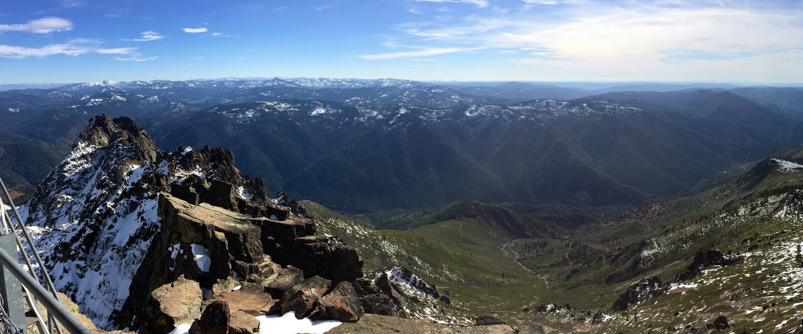
The Sierra Buttes are a dramatic cluster of volcanic spires at the northern edge of the Tahoe National Forest. Somewhat off the beaten path of the Lake Tahoe and High Sierra around Yosemite to the south, the Sierra Buttes are one of the most under rates spots on the Pacific Crest. An old forest service fire lookout sits at the summit, 4,000 feet above Sierra City and the Yuba River to the south and over 2,500 feet above the Sardine Lakes to the northeast with excellent views in all directions. There are a few options for climbing the summit, including a long climb up the south and west face from Sierra City along the PCT, and a few options converging on the north ridge. In the summer a 5 mile round trip is possible from Butcher Ranch Road above Packer Lake Saddle. We opted for a 7 mile route from near Packer Lake north east of the summit and passing Tamarack Lakes en route to the north ridge.
Wednesday, October 26, 2016
Mt Lola Trail
Near: Truckee
Trip Type: Hike
Distance: 10 miles (low estimate)
Elevation: 6,600 - 9,100 feet
Vegetation: Pine Forest
Surface: Dirt (and snow)
Last Visit: October 2016

It's October and the summer hiking season is coming to a close. We headed out to Tahoe National Forest just after the first snows of the season hit the region. We hiked Mt. Lola, an unassuming peak, just off the PCT north of the Donner Pass area. At a bit over 9,100 feet, Mt. Lola is the highest peak between I-80 and Mt. Lassen, yet it's usually overshadowed by all the more dramatic peaks around Lake Tahoe just to the southeast. The usual ascent from the north is a steady climb up a pleasant, but unremarkable creek drainage. The real payoff comes at the peak with fantastic views of the spires of Castle Peak to the south, and Sierra Buttes to the north.
Wednesday, October 5, 2016
Big Rock Ridge (Marin)
Near: Lucas Valley
Trip Type: Hike
Distance: 7 miles
Elevation: 600 - 1,900 feet
Vegetation: Pasture
Last Trip: October 2016

Big Rock Ridge is one of the higher ridges north of Mt. Tam in the Marin county open space. This very exposed hike is mostly nothing special, and communications towers at the summit mar the climax a bit, but the views south to Mt. Tam and San Fransisco, as well as east over the San Fransisco Bay are worth the climb if you've already seen the more unique trails and vistas on Mt. Tam and around the Marin Headlands. The climb is very steady and well graded, so this would be an excellent option for a trail run. Mountain bikes are common too, but all dogs must be on a leash, so that would make a ride plus dog a bit awkward.
Monday, September 26, 2016
Volmer Peak Loop
Near: Berkeley
Trip Type: Trail Run
Distance: 7.5 miles
Elevation: 700 - 1,800 ft
Vegetation: Mostly forested with a mix of deciduous, pine and grassy meadows
Surface: Hardpack dirt

Tuesday, August 30, 2016
Mission Peak
Near: Freemont
Trip Type: Hike
Distance: 5 miles
Elevation: 400 - 2500 ft
Vegetation: Pasture
Surface: Dirt
Last Visit: Sometime in 2014
Mission Peak Regional Preserve is no pristine wilderness. It's yet-another-East-Bay-dirt-road-grass-and-cows experience. Still, its proximity to Bay Area population centers and its satisfying prominence make it worth a visit when you're in the mood for a substantial climb, but not a substantial drive. It's also the far western terminus of the Ohlone Wilderness Trail, so this is the place to start if you want to go on a 28-mile trek into the East Bay hills with several thousand feet of climbing. Personally, if I'm going to do that much work, the Sierras or Trinity Alps better be involved, but if you live in the SF Bay and want to go backpacking with a dog on a strict carbon-footprint budget, then the Ohlone is the trail for you.Wednesday, August 24, 2016
Rodeo Beach, Wolf Ridge Loop, and Costal Trail from Muir Beach
Near: Sausalito
Trip Type: Hike
Length: 5 miles
Elevation: 0 - 800 ft
Vegetation: Coastal scrub
Surface: Paved and dirt
Last Visit: 8/20/16

Rodeo Beach and Muir Beach are some of the most scenic beaches north of San Francisco and both are dog friendly and the trails around these beaches are the nicest of the few dog friendly options in the Marin headlands. The most natural circuit is to climb up and around "hill 88" above Rodeo beach and explore the old WWII fortifications guarding the Golden Gate (voice control OK on this loop). For the best sweeping ocean views, start at Muir Beach and hike south along the Costal Trail (leash required).
Subscribe to:
Posts (Atom)